
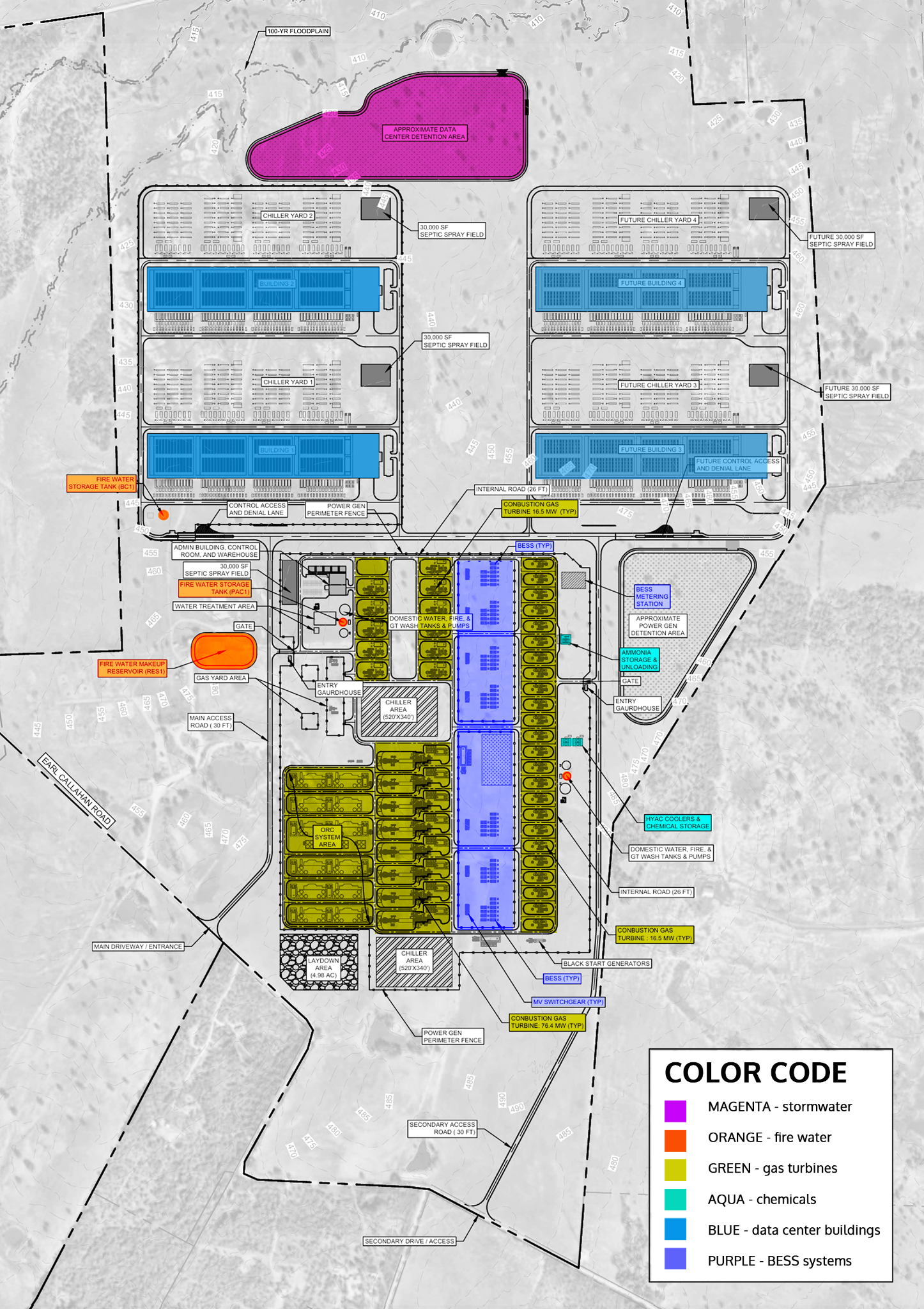
Two gas-turbine rating labels; BESS; ORC; ammonia, chemical, cooling, fire-water, wastewater, and detention areas; and four data-center buildings, two marked future.
Verified GIS
See what surrounds the proposed Pacifico site.
The Pacifico layer uses the eight exact tracts listed in J0049, with an optional georeferenced overlay of the OSSF-derived conceptual site plan. The map also shows the eastern FM 535 project and host parcels—including filed-address locators for Campus 2 and Campus 3—the MPH Bastrop Peakers host parcel, Earth Native's full five-parcel tract and shared property line, all 25 schools and early-childhood facilities, and 20 SpaceX / Gapped Bass parcels near FM 1209, FM 969 and Doc Bryson Lane. Three earlier ownership records are dashed and labeled unconfirmed. Separately, 3 resident-reported sales parcels have dotted amber outlines; the ranch's Musk connection and the Bar W pending sale remain unconfirmed. Privacy-safe community opposition, residential, drought, fire, and response context are also available. Two optional Central Texas layers add utility-scale power generation and large-scale data centers, with source-dated status and approximate locations labeled.
Content reviewed October 20, 2026 · Evidence dates appear with the records.
Verified GIS
See what surrounds the proposed Pacifico site.
The Pacifico layer uses the eight exact tracts listed in J0049.
Read moreRead less
An optional georeferenced overlay of the OSSF-derived conceptual site plan is available. The map also shows the eastern FM 535 project and host parcels—including filed-address locators for Campus 2 and Campus 3—the MPH Bastrop Peakers host parcel, Earth Native's full five-parcel tract and shared property line, all 25 schools and early-childhood facilities, and 20 SpaceX / Gapped Bass parcels near FM 1209, FM 969 and Doc Bryson Lane. Three earlier ownership records are dashed and labeled unconfirmed. Separately, 3 resident-reported sales parcels have dotted amber outlines; the ranch's Musk connection and the Bar W pending sale remain unconfirmed. Privacy-safe community opposition, residential, drought, fire, and response context are also available. Two optional Central Texas layers add utility-scale power generation and large-scale data centers, with source-dated status and approximate locations labeled.
Content reviewed October 20, 2026 · Evidence dates appear with the records.
Interactive regional map
Homes, 25 schools and learning facilities, major power projects, industrial parcels, drought, fire history—and response infrastructure
Pacifico, the Black Mountain / FWPC / ECX AUS31 parcel set, MPH Bastrop Peakers, Earth Native, school and childcare, SpaceX / Gapped Bass, residential, and public-community layers are on by default. Use Show local opposition for the privacy-safe broad-area totals, or open the layer control to add current drought intensity, farms and agricultural sites, ESD No. 1 station sites, the conceptual Pacifico layout, and other context. Opposition areas are intentionally generalized and are not household locations. Ownership parcels and the registered plan are not survey-grade or final building footprints, and jurisdiction boundaries do not establish staffing, apparatus, response time, water supply, or industrial-fire capability.
New: Central Texas power and data centers. Open the layer control to enable either regional layer. Both start off and keep the current zoom when enabled. Local regional pins may separate for selection, with limited dashed lines back to their recorded locations. Wide-area views allow overlap to preserve the geographic pattern. Use View Central Texas sites only when you want to zoom out.
Loading the verified GIS workspace…
Voluntary community opposition
106 supporters represented
The initial list represents 29 people at at least 16 locations. Exact street addresses are used only for private review and are never displayed publicly. The map shows anonymous totals inside fixed broad areas—not household pins or address-derived points.
106people opposing the proposal
86+represented locations
3broad map areas
What the count means
This is a voluntary supporter list, not a poll or a claim that every nearby resident agrees. Bubble locations and boundaries are fixed in advance and do not move in response to a submitted address.
Duplicate entries in the launch list were consolidated. New entries require a one-person attestation, confirmation through the private contact email, and organizer review against the launch list and queue. Multiple adults at one location may count as separate supporters, while the location counts once.
Lost Pines Watch does not ask for, collect or publish supporter names through this feature. After organizer approval, an anonymous count can be added to the selected broad-area bubble immediately; there is no five-entry batch or seven-day waiting period.
Count updated October 21, 2026OSSF-derived site plan
What the site layout appears to show
This colorized community annotation is based on “PACIFICO site plans 2 - stitched 1.png,” a stitched plan derived from the project’s on-site sewage facility filing. It helps separate the data-center, power, water, chemical, stormwater, and wastewater systems. The color is explanatory—not part of the filing.
Source-file note
The uncolored source is preserved as PACIFICO site plans 2 - stitched 1.png. The colorized version is an interpretive overlay of that OSSF-derived image, not a replacement for it.
Equipment maker or model, final unit count, BESS capacity or duration, fuel route, emissions and noise totals, water balance, construction sequence, or operating schedule.
“TYP” usually means a label or detail applies to similar repeated features. It is not, by itself, a final count or proof that every repeated symbol will be built.
Site plan guideExplanation of Site Components
Open the guide to see how the labeled systems probably work together, separating what the plan expressly labels from technically reasonable interpretation and details Pacifico has not disclosed.
Explore
Explanation of Site Components
Open the guide to see how the labeled systems probably work together, separating what the plan expressly labels from technically reasonable interpretation and details Pacifico has not disclosed.
01
Direct Pacifico contractStrong 76.4 MW candidate: Ansaldo AE64.3A
- Shown
- “Combustion gas turbine: 76.4 MW (TYP)” and “combustion gas turbine: 16.5 MW (TYP).” The drawing does not identify the rating basis, manufacturer, or model.
- Likely function
- Different unit sizes could let an operator add generation in smaller steps, retain capacity during maintenance, and follow a changing campus load. That is a plausible design benefit—not a disclosed dispatch plan or proof of baseload-versus-peaking roles.
- Strongest model evidence
- Ansaldo Energia announced on July 20, 2026 that Pacifico Energy ordered exactly eight AE64.3A turbines in a 60 Hz configuration, with generators, for a Texas data-center power project. This plan appears to repeat eight larger turbine packages, while Ansaldo’s current brochure rates the AE64.3A at 78 MW under natural-gas ISO conditions. The plan’s 76.4 MW label is 1.6 MW, or about 2.1%, lower—a close match that could reflect a project-specific or net rating. Taken together, the developer, state, application, unit count, equipment class, and rating make the AE64.3A the strongest candidate found for the larger units.
- Confidence limit
- Ansaldo’s announcement does not name Cedar Creek, and Pacifico has more than one Texas data-center project. The OSSF-derived plan also does not state its rating basis or identify a manufacturer. This is therefore a strongly supported candidate—not a site-confirmed procurement record. The 16.5 MW model remains unresolved: its rating is close to the Solar Titan 130’s 16.53 MW ISO output and the Baker Hughes NovaLT16’s 16.9 MW power-generation output, but capacity alone cannot distinguish them.
02
Likely functionBESS, metering, and medium-voltage switchgear
- Shown
- Repeated “BESS (TYP)” areas, a BESS metering station, and “MV switchgear (TYP)” inside the power block.
- Likely function
- Battery storage could supply rapid-response power, bridge short changes while generators start or ramp, support ride-through, and stabilize an islanded campus. Switchgear would protect, isolate, and route medium-voltage circuits; the metering station would measure battery power exchange.
- Still unknown
- Battery chemistry, MW, MWh, duration, container count, operating purpose, electrical topology, setbacks, and fire-protection design.
03
High-confidence readingORC system area
- Shown
- A large “ORC system area” directly beside the larger turbine footprints.
- Likely function
- ORC most likely means Organic Rankine Cycle: a bottoming system that captures otherwise-wasted heat and converts some of it to additional electricity. Its placement makes turbine-exhaust heat recovery the most likely explanation.
- Still unknown
- Heat-source connections, working fluid, generating capacity, condenser and cooling method, or whether the ORC is included in either turbine MW label.
04
Likely emissions controlAmmonia storage and unloading
- Shown
- A dedicated “ammonia storage & unloading” area inside the power-generation fence.
- Likely function
- The most likely use is reagent supply for selective catalytic reduction, which injects ammonia or urea into exhaust to reduce nitrogen oxides. EPA identifies SCR as a widely used gas-turbine NOx control.
- Still unknown
- Ammonia concentration, storage volume, unloading frequency, containment and emergency safeguards, SCR layout, and permitted NOx or ammonia-slip limits.
05
Likely functionGas yard, black start, and plant restart
- Shown
- A gas-yard area near the main entrance and labeled black-start generators near the switchgear.
- Likely function
- The gas yard would normally receive, meter, regulate, and condition fuel before it reaches the turbines. Black-start generators can energize essential plant equipment after a full shutdown without relying on the outside transmission network.
- Still unknown
- Pipeline route, delivery pressure, on-site gas compression, backup fuel, black-start generator type, rating, fuel, and runtime.
06
Two cooling contextsChillers, HVAC coolers, and water systems
- Shown
- Chiller Yards 1 and 2 beside Buildings 1 and 2; Future Chiller Yards 3 and 4; two 520-by-340-foot chiller areas in the power block; HVAC coolers and chemical storage; water treatment; and domestic, fire, and gas-turbine-wash tanks and pumps.
- Likely function
- The data-center chiller yards would reject heat from IT equipment. The separately fenced power-block cooling areas likely serve turbine, generator, ORC, inlet-air, or other plant auxiliaries. The labeled wash-water system likely supports turbine compressor cleaning.
- Still unknown
- Air-cooled versus evaporative equipment, design heat load, water consumption, chemical inventory, blowdown handling, redundancy, or which loads each power-block chiller serves.
07
Different water systemsFire water, septic spray fields, and detention
- Shown
- Two fire-water storage tanks, a fire-water makeup reservoir, four 30,000-square-foot septic spray fields near the data halls, another 30,000-square-foot field in the power area, and separate data-center and power-generation detention areas.
- Likely function
- The fire-water features reserve water for suppression and system refill. OSSF spray fields disperse treated wastewater on site; they are not cooling ponds. Detention areas temporarily manage stormwater runoff.
- Still unknown
- Tank and reservoir volumes, refill source and rate, fire demand, wastewater design flow, treatment train, spray schedule, stormwater outlet design, or final authorization.
08
Sequence suggestedPhasing, access, and operations
- Shown
- Buildings and Chiller Yards 3 and 4 are marked “future.” The plan also shows fences, gates, guardhouses, control and denial lanes, an admin/control/warehouse building, internal roads, secondary access, and a 4.98-acre laydown area.
- Likely function
- The labels suggest staged data-center buildout while the access and laydown features support controlled construction, deliveries, maintenance, and daily industrial operations.
- Still unknown
- Formal phase boundaries, start dates, construction duration, staffing, truck volumes, gate schedules, emergency access, or whether power generation is phased with the data halls.
Bottom line
The plan strongly supports a tightly integrated data-center and on-site power campus with multiple turbine sizes, battery storage, heat recovery, probable emissions-control support, and substantial cooling and water infrastructure. The drawing itself does not identify a turbine model. A separate Ansaldo–Pacifico contract was once the strongest candidate evidence for the 76.4 MW units. The released air application now separately identifies 48 turbines across six model families, including eight Ansaldo AE64.3A units, and states 1,326 MW of maximum nominal output. The drawing does not establish final procurement, exact placement, operating profile, impacts, or approved terms.
Layer registerWhat is mapped—and what still requires evidence
Parcel, address-point, public-facility, and fire layers carry separate evidence labels. Residential records are deliberately stripped to coordinates only. Derived layers and incomplete reconciliations remain explicit.
Explore
What is mapped—and what still requires evidence
Parcel, address-point, public-facility, and fire layers carry separate evidence labels. Residential records are deliberately stripped to coordinates only. Derived layers and incomplete reconciliations remain explicit.
| Theme | Layer | Status | Source or requirement |
|---|---|---|---|
| Regional projects | Central Texas utility-scale power generation | Dated EIA snapshot + project records | Generation sites of at least 10 MW, plus proposals with unverified capacity; all fuels and development stages. Optional; preserves the initial map view. |
| Regional projects | Central Texas large-scale data centers | Source-linked campus inventory | Operating campuses, construction and publicly documented proposals; approximate locations explicitly labeled. Optional; does not change the initial map view. |
| Project | Pacifico filed project area | Verified snapshot | Eight exact J0049 tracts + Bastrop County GIS geometry |
| Project | Conceptual Pacifico site layout | Derived | OSSF-derived applicant plan affinely aligned to fixed aerial features; approximate, not a survey or final construction footprint |
| Adjacent land | Earth Native full tract and shared property line | Verified snapshot | Five contiguous CAD parcels totaling 103.721 legal acres; approximately 2,160-foot shared line with J0049 parcel 24484 |
| Projects | SpaceX and Gapped Bass parcels | CAD + recorded deed + labeled prior records | 20 mapped parcels near FM 1209 / FM 969 and Doc Bryson Lane; 17 confirmed current-owner records total 1,202.467 CAD legal acres. Parcel 121670 is confirmed by SpaceX deed 202609629, recorded June 8, 2026, despite an outdated CAD owner field. 3 prior records remain dashed. Updated September 27, 2026. |
| Manufacturing | SpaceX factory · aluminum furnace permit | Primary records; permit pending | SX marker: TCEQ facility point for 858 FM 1209, RN111897583. Permit 182733 covers aluminum melting and holding furnaces. Separate SpaceX job postings confirm Bastrop turbine-blade plans, but the foundry parcel and a link to this permit remain unconfirmed. Checked October 1, 2026. |
| Reported sales | Colorado River Ranch and Bar W Ranch parcels | Resident-reported; key claims unconfirmed | 3 dotted amber outlines, excluded from confirmed SpaceX / Gapped Bass totals. Parcel 133579 (314.17 acres): sale to Colorado River Ranch LLC recorded June 1, 2026; Musk connection reported, not confirmed. Bar W parcels 51141 (453.384 acres) and 35704 (347.862 acres): resident-reported pending sale; buyer and pending status unconfirmed. |
| Projects | EdgeConneX site and host tracts | CAD-derived snapshot | AUS01 Unit 1/common area (~63.45 mapped acres) and Units 2–4 (~37.96 mapped acres), with LCRA parcel 24749 excluded; checked October 1, 2026. Plus the 179-acre 6682 FM 535 tract used by EDCAUS11, EDCAUS12, EDCAUS13 and EDCAUS14 |
| Projects | Eastern FM 535 project and host parcels | Current CAD/deed snapshot | R35120 and R25532 are EdgeConneX Property 7-owned; R34648 hosts the EDCAUS31/32 filed address and R55674 hosts the EDCAUS15/16 filed address while remaining Uppingham-owned and dashed. Four-parcel total: 3,178.588 legal acres. |
| Projects | Amazon Data Services assemblage | CAD-derived snapshot | Historical CTX/Creekside assemblage (~1,327 mapped acres); exact current Amazon ownership and conveyance remain under deed reconciliation |
| Projects | MPH Bastrop Peakers host parcel | Verified snapshot | Bastrop CAD property 85993; permitted 1,170 MW expansion; TCEQ air permits signed March 25, 2026; J0033 remains in Application Phase |
| Projects | AUS02 and eight EDCAUS filings at three address locators | Verified | TDLR filings for AUS02, EDCAUS11, EDCAUS12, EDCAUS13, EDCAUS14, EDCAUS15, EDCAUS16, EDCAUS31 and EDCAUS32 + verified address points |
| Community | Voluntary opposition shown in broad areas | Community list + moderated opt-ins | 29 people in the launch count; no names are collected, and exact addresses are never displayed publicly |
| Community | Anonymous residential address points | Privacy-safe snapshot | 5,701 points within 3 miles; all names, addresses, ownership, and submissions removed |
| Community | Schools and childcare | Mixed verification | All 25 schools and early-childhood facilities, with current names, addresses, licensing evidence, co-locations, and unconfirmed records labeled separately |
| Community | Farms and agricultural sites | Privacy-safe snapshot | Named public farms + anonymized county-classified agricultural points |
| Community | Churches, parks, cemeteries, care and response sites | Reference snapshot | Public-place locations from the supplied community-impact dataset |
| Environmental stress | Current U.S. Drought Monitor intensity | Live | Latest weekly USDM polygons; select a feature for its own classification, valid date and release date |
| Fire | 2011 Bastrop Complex perimeter | Verified snapshot | Bastrop County GIS |
| Fire | 2015 Hidden Pines perimeter | Verified snapshot | Bastrop County GIS |
| Emergency | Bastrop County ESD No. 1 station sites | Verified snapshot | 7 recorded facilities across a 395-square-mile response area; Texas FireConnect verified February 6, 2026 |
| Emergency | Five-mile station distance guides | Derived | Straight-line facility proximity only; not drive time, response time, staffing, or capability |
| Emergency | Fire service and responder boundaries | Live | Bastrop County GIS |
| Analysis | 1 / 2 / 3 / 5 mile perimeter offsets | Derived | Measured outward from Pacifico’s filed project boundary |
| Projects | Amazon conveyed-tract deed reconciliation | Verify | The CAD-derived approximately 1,300-acre union is mapped; recorded deeds remain authoritative for the exact conveyance |
| Risk | Wildland fuel models | Next | Texas A&M Forest Service / LANDFIRE |
| Infrastructure | Transmission and substations | Researching | ERCOT, utilities, county records |
| Infrastructure | Natural-gas pipelines | Researching | RRC and operator records |
| Water | Wells, service areas, and supply | Researching | LPGCD, Aqua WSC, TWDB |
| Mobility | Roads, access, and evacuation | Researching | TxDOT and county records |
| Community | Exact supporter addresses, emails, and unapproved submissions | Never public | Only anonymous counts inside fixed broad-area bubbles are displayed |
School and early-childhood register25 mapped school, childcare and learning-program entries—within about four miles
4 are within about one mile. Some entries have unconfirmed current operating status. Earth Native Wilderness School is immediately adjacent, and its property shares the project boundary. Co-located programs have separate selectable markers; tiny display offsets do not change their listed addresses or measured distances.
Explore
25 mapped school, childcare and learning-program entries—within about four miles
4 are within about one mile. Some entries have unconfirmed current operating status. Earth Native Wilderness School is immediately adjacent, and its property shares the project boundary. Co-located programs have separate selectable markers; tiny display offsets do not change their listed addresses or measured distances.
| # | School or early-childhood facility | Public address | Distance | Evidence status |
|---|---|---|---|---|
| 1 | Cedar Creek Elementary School Bastrop ISD elementary campus | 5582 FM 535, Cedar Creek, TX 78612 | 3.2 mi | Verified current campus Current Bastrop ISD directory address. |
| 2 | Cedar Creek Intermediate School / Creekside Middle School Bastrop ISD middle-school campus | 151 Voss Pkwy, Cedar Creek, TX 78612 | 2.2 mi | Verified address; current name corrected Bastrop ISD currently identifies the 151 Voss campus as Creekside Middle School; Cedar Creek Intermediate is retained as an alternate name. |
| 3 | Cedar Creek Middle School Bastrop ISD middle-school campus | 125 Voss Pkwy, Cedar Creek, TX 78612 | 2.1 mi | Verified current campus Current Bastrop ISD directory address. |
| 4 | Cedar Creek High School Bastrop ISD high-school campus | 793 Union Chapel Rd, Cedar Creek, TX 78612 | 3.8 mi | Verified current campus Current Bastrop ISD directory address. |
| 5 | Covenant Christian School Private school | 120 N Gaines Rd, Cedar Creek, TX 78612 | 1.0 mi | Current operation unconfirmed The resident-supplied address geocodes exactly, but a current operating-school record was not independently located. |
| 6 | Learning Lions Christian School Private early-childhood school | 1168 Walter Hoffman Rd, Cedar Creek, TX 78612 | 1.0 mi | Verified current program The school publishes this address and describes full-time care for ages 2–5. |
| 7 | Colony Oaks Elementary School Bastrop ISD elementary campus | 601 Sam Houston Dr, Bastrop, TX 78602 | 3.0 mi | Verified current campus Current Bastrop ISD directory address. |
| 8 | Adelton Elementary Bastrop ISD elementary campus | 119 Blume Dr, Bastrop, TX 78602 | 2.5 mi | Verified current campus Bastrop ISD lists 119 Blume Drive; the new street is not yet resolved by the public geocoder, so the campus point uses the district's previously published map location. |
| 9 | Calvary Episcopal School Private Episcopal school | 107 Lost Oaks Trail, Bastrop, TX 78602 | 3.7 mi | Verified current campus Spelling corrected from 'Cavalry.' The school moved to this campus in January 2026. |
| 10 | Founders Classical Academy – Bastrop Public charter school | 415 Shiloh Rd, Bastrop, TX 78602 | 2.2 mi | Verified current campus The academy's current official Bastrop page lists this address. |
| 11 | Earth Native Wilderness School / Wild Life Forest Preschool Outdoor education and forest preschool campus | 921 Shiloh Rd, Bastrop, TX 78602 | 0.1 mi | Verified current campus Earth Native publishes both Shiloh and Woodview entrances and states that its program is not a licensed child-care facility. |
| 12 | Children's Town Center Licensed child-care center | 112 Voss Pkwy, Cedar Creek, TX 78612 | 2.0 mi | Licensing-search location Public child-care licensing search location; verify current details in the state record. |
| 13 | Sweetpea Learning Center Licensed child-care center | 104 Union Chapel Rd, Cedar Creek, TX 78612 | 1.0 mi | Licensing-search location Public child-care licensing search location; verify current details in the state record. |
| 14 | Cedar Creek Child Care Center Licensed child-care center | 5630 FM 535, Cedar Creek, TX 78612 | 3.3 mi | Licensing-search location Public child-care licensing search location; verify current details in the state record. |
| 15 | Cedar Creek Head Start Head Start / early-childhood program | 5582 FM 535, Cedar Creek, TX 78612 | 3.2 mi | Current program record unconfirmed This co-location is mapped, but a current standalone Head Start record at this campus was not independently verified. |
| 16 | BISD District Day Care @ Cedar Creek Elementary Bastrop ISD child development center | 5582 FM 535, Cedar Creek, TX 78612 | 3.2 mi | Verified district co-location Cedar Creek Elementary's official page says the campus houses one of Bastrop ISD's two Child Development Centers. |
| 17 | BISD Cedar Creek Middle Daycare School-based child-care program | 151 Voss Pkwy, Cedar Creek, TX 78612 | 2.2 mi | Current program record unconfirmed This co-location is mapped. Bastrop ISD currently calls this campus Creekside Middle School, and a current daycare program record was not independently located. |
| 18 | BISD Beyond the Bell / STARS at Cedar Creek Elementary Bastrop ISD after-school program | 5582 FM 535, Cedar Creek, TX 78612 | 3.2 mi | Verified district co-location The campus bell schedule identifies STARS dismissal; the marker is offset only so the co-located program can be selected. |
| 19 | Small Treasures In-Home Child Care Registered or listed in-home child care | 204 Martin Crossing Dr, Cedar Creek, TX 78612 | 0.6 mi | Licensing-search location This is a public-facing child-care operation address from the state search; no resident or household ownership data are attached. |
| 20 | Busy Bee Academy Licensed child-care center | 1116 Highway 71 W, Bastrop, TX 78602 | 1.5 mi | Verified state operation Texas child-care operation 1627657; address independently cross-checked. |
| 21 | Legacy Educational Center (Legacy Childcare) Licensed child-care center | 636 Highway 304, Bastrop, TX 78602 | 3.6 mi | Verified state operation The current Bastrop record is Legacy Educational Center, Texas child-care operation 1803399; Legacy Childcare is retained as an alternate name. |
| 22 | Bastrop Montessori Private Montessori school and preschool | 875 Highway 71 W, Bastrop, TX 78602 | 2.4 mi | Verified current campus The school’s current website lists this campus, programs for ages 18 months through sixth grade, and a 2026–27 school calendar. |
| 23 | Bluebonnet Elementary School Bastrop ISD elementary campus | 416 FM 1209, Bastrop, TX 78602 | 2.5 mi | Verified current campus The official campus page lists this address; its location was checked with an exact public address-geocoder match on September 22, 2026. |
| 24 | Compass Rose Harvest Public charter school | 118 Stephen F. Austin Blvd, Bastrop, TX 78602 | 1.7 mi | Verified current campus The official campus page lists this address; its location was checked with an exact public address-geocoder match on September 22, 2026. |
| 25 | Childrens Town Center #2 Licensed child-care center | 374 FM 1209, Bastrop, TX 78602 | 2.2 mi | Verified active license HHSC operation 1487297: active, capacity 60, full permit issued February 18, 2025; checked October 1, 2026. Separate from the 112 Voss Pkwy center. Exact address-geocoder match; distance measured to Pacifico’s filed tract boundary. |
Pacifico tract registerThe eight tracts identified in the application
J0049 page 7 identifies each Bastrop County Appraisal District property ID, legal description, and common project address. These are the tracts rendered in the live Pacifico layer.
Explore
The eight tracts identified in the application
J0049 page 7 identifies each Bastrop County Appraisal District property ID, legal description, and common project address. These are the tracts rendered in the live Pacifico layer.
| Property ID | Legal description | Filed acreage | Map status |
|---|---|---|---|
| 24484 | A225 LEVERENCE, L. | 1,451.6100 acres | Mapped |
| 73556 | A225 LEVERENCE, L. | 61.7334 acres | Mapped |
| 82519 | A225 LEVERENCE, L. | 291.1566 acres | Mapped |
| 42020 | A338 WALTERS, JACOB | 993.4300 acres | Mapped |
| 73320 | A225 LEVERENCE, L. | 1.5126 acres | Mapped |
| 90755 | A83 BYMER, BERNARD | 2.8550 acres | Mapped |
| 42286 | A375 LITTON, ADDISON | 7.6300 acres | Mapped |
| 92335 | A83 BYMER, BERNARD | 0.1277 acres | Mapped |
| Filed legal-description total | 2,810.0553 acres | Applicant narrative states approximately 2,842 acres | |
Regional projects · inventory reviewed October 20, 2026Central Texas power generation, data centers and permit records
Explore operating, under-construction and proposed projects across Central Texas, plus equipment and emissions records for nearby power plants. Status, location accuracy and evidence dates are labeled separately.
Explore
Central Texas power generation, data centers and permit records
Explore operating, under-construction and proposed projects across Central Texas, plus equipment and emissions records for nearby power plants. Status, location accuracy and evidence dates are labeled separately.
Regional project inventory
84 generation records and 49 data center projects across 31 counties, with scope and source links below.
Reviewed October 20, 2026. The power baseline is the August 2026 EIA-860M operating and planned generator inventory, supplemented by dated project records. This map shows generation sites with at least 10 MW of reported operating or proposed generating capacity, plus labeled major proposals whose capacity remains undisclosed or unverified. Large on-site generation and combined heat and power are included. Sites with known capacity below 10 MW, storage-only sites and retired sites are excluded. Data centers include major hyperscale, colocation, AI and industrial computing campuses, including labeled cryptocurrency sites. This is a documented inventory rather than an exhaustive registry; private or undisclosed proposals may be missing.
Study area (31 counties): Bastrop, Bell, Bexar, Blanco, Burleson, Burnet, Caldwell, Colorado, Comal, Coryell, Falls, Fayette, Gillespie, Gonzales, Guadalupe, Hamilton, Hays, Kendall, Kerr, Lampasas, Lavaca, Lee, Llano, Mason, McLennan, Milam, Mills, San Saba, Travis, Washington, Williamson.
Status is the latest evidence found for each record, not a live construction inspection. A filed start date or announced target does not prove construction. Operating campuses may also have proposed expansions. Approximate town or area pins do not identify a particular property; none of these points is a surveyed project boundary. Power generation, critical IT load, utility service and possible full buildout are different measures and should not be added together. A substation does not generate electricity, and a nearby power plant is not necessarily dedicated to a data center. The Caldwell Power Generation Plant filing is flagged because its capacity and operating role are unverified. Austin Energy’s announced 400 MW peaker program uses an Austin-area placeholder because its sites have not been disclosed.
Power generation sites
Bastrop County Power Plant / Fort Worth Power Core
Planned / permitting / discussion · Bastrop County
Permitted / construction unconfirmed; Permitted / construction unconfirmed
Natural gas · Natural gas generation · Capacity unreported / not verified
Location: TCEQ registered coordinate 30.116,-97.556; not an equipment survey
Operator: Original applicant:Fort Worth Power Core LLC. Registration 178505 issuedDecember 20, 2024, expiresDecember 20, 2034. Six gas combustion turbine generators and two heat-recovery steam generators authorized. Capacity measures reported elsewhere differ; not assigned here without reconciling permit rating. Point is TCEQ registered location inside EdgeConneX Property 7 parcel R35120. Does not prove equipment construction or current customer-record affiliation.
Evidence date: Reviewed October 20, 2026
TCEQ issuance letter and emissions tableBastrop CAD R35120Bastrop Energy Center
Operating · Bastrop County
Operating (EIA August 2026); (OP) Operating
Natural gas · Natural Gas Fired Combined Cycle · 618.7 MW generator nameplate
Location: EIA-reported plant coordinate; not a surveyed boundary
Operator: Bastrop Energy Partners, LP. EIA sector: IPP Non-CHP. Includes generators reported operating in EIA-860 M; standby, out-of-service, retired and storage units excluded.
Evidence date: EIA August 2026 snapshot, released September 24, 2026; reviewed October 20, 2026
EIA-860M August 2026 inventory (released September 24, 2026)EIA inventory methodologyBig Star Solar, LLC (Hybrid)
Operating · Bastrop County
Operating (EIA August 2026); (OP) Operating
Solar · Solar Photovoltaic · 200 MW generator nameplate
Location: EIA-reported plant coordinate; not a surveyed boundary
Operator: RWE Clean Energy. EIA sector: IPP Non-CHP. Includes generators reported operating in EIA-860 M; standby, out-of-service, retired and storage units excluded.
Evidence date: EIA August 2026 snapshot, released September 24, 2026; reviewed October 20, 2026
EIA-860M August 2026 inventory (released September 24, 2026)EIA inventory methodologyLost Pines 1 Power Project
Operating · Bastrop County
Operating (EIA August 2026); (OP) Operating
Natural gas · Natural Gas Fired Combined Cycle · 609 MW generator nameplate
Location: EIA-reported plant coordinate; not a surveyed boundary
Operator: Lower Colorado River Authority. EIA sector: Electric Utility. Includes generators reported operating in EIA-860 M; standby, out-of-service, retired and storage units excluded.
Evidence date: EIA August 2026 snapshot, released September 24, 2026; reviewed October 20, 2026
EIA-860M August 2026 inventory (released September 24, 2026)EIA inventory methodologyMPH Bastrop Peakers expansion
Planned / permitting / discussion · Bastrop County
Permitted expansion / construction unconfirmed; Permitted expansion / construction unconfirmed
Natural gas · Natural gas generation · Up to 1,170 MW proposed
Location: Approximate site/campus point; equipment footprint not confirmed
Operator: MPH Bastrop Peakers LLC / MilePost Power. Six additional gas turbines at 195 MW each proposed within existing Bastrop Energy Center host property. TCEQ permits 178585, PSDTX1658, GHGPSDTX247 signedMarch 25, 2026 per existing linked site record. Existing plant is separately mapped from EIA;1,170 MW here is additional proposed capacity, not current output. Filed start dates and signed permits do not prove construction has begun.
Evidence date: Reviewed October 20, 2026
TCEQ preliminary determinationLost Pines Watch mapped permit and parcel recordPacifico Cedar Creek proposed power plant
Planned / permitting / discussion · Bastrop County
Proposed / air-permit application; Proposed / air-permit application
Natural gas · Natural gas generation · Up to 1,326 MW proposed
Location: Approximate site/campus point; equipment footprint not confirmed
Operator: Pacifico Energy / Pacifico Cedar Creek Power. Filed air application describes 48 gas turbines totaling 1,326 MW maximum nominal output. Older JETI 710 MW figures describe an earlier proposal. Approximate campus point, not final turbine pads. Onsite generation proposed to serve associated data center. Governor-directed permit pause does not mean canceled.
Evidence date: Reviewed October 20, 2026
Released Pacifico air application · 48 turbines / 1,326 MWTCEQ Project 413471 / Registration 185019Original J0049 application (earlier710 MW concept)Permitting pause context and sourcesSim Gideon
Operating · Bastrop County
Operating (EIA August 2026); (OP) Operating
Natural gas · Natural Gas Steam Turbine · 623 MW generator nameplate
Location: EIA-reported plant coordinate; not a surveyed boundary
Operator: Lower Colorado River Authority. EIA sector: Electric Utility. Includes generators reported operating in EIA-860 M; standby, out-of-service, retired and storage units excluded.
Evidence date: EIA August 2026 snapshot, released September 24, 2026; reviewed October 20, 2026
EIA-860M August 2026 inventory (released September 24, 2026)EIA inventory methodologyBig Elm Solar
Operating · Bell County
Operating (EIA August 2026); (OP) Operating
Solar · Solar Photovoltaic · 200 MW generator nameplate
Location: EIA-reported plant coordinate; not a surveyed boundary
Operator: Big Elm Solar, LLC. EIA sector: IPP Non-CHP. Includes generators reported operating in EIA-860 M; standby, out-of-service, retired and storage units excluded.
Evidence date: EIA August 2026 snapshot, released September 24, 2026; reviewed October 20, 2026
EIA-860M August 2026 inventory (released September 24, 2026)EIA inventory methodologyChillingham Solar
Operating · Bell County
Operating (developer project page); ENGIE project page lists solar commercial operation 2024; EIA August 2026 entry remains commissioning.
Solar · Solar Photovoltaic · 350 MW generator nameplate
Location: EIA-reported plant coordinate; not a surveyed boundary
Operator: Chillingham Solar LLC. EIA sector: IPP Non-CHP. Developer schedule/status reported to EIA. Planned operation dates and permit activity do not establish construction or commercial operation. Operator page contains conflicting introductory county/year boilerplate; use EIA Bell County coordinates and explicit commercial-operation field. Solar 350 MW; paired 150 MW storage excluded.
Evidence date: EIA August 2026 snapshot, released September 24, 2026; reviewed October 20, 2026
EIA-860M August 2026 inventory (released September 24, 2026)EIA inventory methodologyENGIE Chillingham: commercial-operation fieldCosper Solar
Planned / permitting / discussion · Bell County
Planned (EIA August 2026); (L) Regulatory approvals pending. Not under construction
Solar · Solar Photovoltaic · 148.2 MW generator nameplate
Location: EIA-reported plant coordinate; not a surveyed boundary
Operator: Gransolar Texas Twenty LLC. EIA sector: IPP Non-CHP. Developer schedule/status reported to EIA. Planned operation dates and permit activity do not establish construction or commercial operation.
Evidence date: EIA August 2026 snapshot, released September 24, 2026; reviewed October 20, 2026
EIA-860M August 2026 inventory (released September 24, 2026)EIA inventory methodologyFive Wells Solar Center - Hybrid
Operating · Bell County
Operating (EIA August 2026); (OP) Operating
Solar · Solar Photovoltaic · 355.4 MW generator nameplate
Location: EIA-reported plant coordinate; not a surveyed boundary
Operator: Five Wells Solar Center, LLC. EIA sector: IPP Non-CHP. Includes generators reported operating in EIA-860 M; standby, out-of-service, retired and storage units excluded.
Evidence date: EIA August 2026 snapshot, released September 24, 2026; reviewed October 20, 2026
EIA-860M August 2026 inventory (released September 24, 2026)EIA inventory methodologyHermes Solar PV
Under construction · Bell County
Construction / commissioning (EIA August 2026); (V) Under construction, more than 50 percent complete
Solar · Solar Photovoltaic · 100.4 MW generator nameplate
Location: EIA-reported plant coordinate; not a surveyed boundary
Operator: Bell 1 Solar, LLC. EIA sector: IPP Non-CHP. Developer schedule/status reported to EIA. Planned operation dates and permit activity do not establish construction or commercial operation.
Evidence date: EIA August 2026 snapshot, released September 24, 2026; reviewed October 20, 2026
EIA-860M August 2026 inventory (released September 24, 2026)EIA inventory methodologyLimewood Bell Renewables Solar
Under construction · Bell County
Construction / commissioning (EIA August 2026); (TS) Construction complete, but not yet in commercial operation
Solar · Solar Photovoltaic · 204 MW generator nameplate
Location: EIA-reported plant coordinate; not a surveyed boundary
Operator: Limewood Bell Renewables LLC. EIA sector: IPP Non-CHP. Developer schedule/status reported to EIA. Planned operation dates and permit activity do not establish construction or commercial operation.
Evidence date: EIA August 2026 snapshot, released September 24, 2026; reviewed October 20, 2026
EIA-860M August 2026 inventory (released September 24, 2026)EIA inventory methodologyPhantom Solar
Operating · Bell County
Operating (EIA August 2026); (OP) Operating
Solar · Solar Photovoltaic · 15.4 MW generator nameplate
Location: EIA-reported plant coordinate; not a surveyed boundary
Operator: Phantom Solar, LLC. EIA sector: IPP Non-CHP. Includes generators reported operating in EIA-860 M; standby, out-of-service, retired and storage units excluded.
Evidence date: EIA August 2026 snapshot, released September 24, 2026; reviewed October 20, 2026
EIA-860M August 2026 inventory (released September 24, 2026)EIA inventory methodologyStillhouse Solar
Operating · Bell County
Operating (EIA August 2026); (OP) Operating
Solar · Solar Photovoltaic · 210 MW generator nameplate
Location: EIA-reported plant coordinate; not a surveyed boundary
Operator: Stillhouse Solar LLC. EIA sector: IPP Non-CHP. Includes generators reported operating in EIA-860 M; standby, out-of-service, retired and storage units excluded.
Evidence date: EIA August 2026 snapshot, released September 24, 2026; reviewed October 20, 2026
EIA-860M August 2026 inventory (released September 24, 2026)EIA inventory methodologyTemple Power Station
Operating · Bell County
Operating (EIA August 2026); (OP) Operating
Natural gas · Natural Gas Fired Combined Cycle · 1,606.4 MW generator nameplate
Location: EIA-reported plant coordinate; not a surveyed boundary
Operator: Temple Generation Holdings LLC. EIA sector: IPP Non-CHP. Includes generators reported operating in EIA-860 M; standby, out-of-service, retired and storage units excluded.
Evidence date: EIA August 2026 snapshot, released September 24, 2026; reviewed October 20, 2026
EIA-860M August 2026 inventory (released September 24, 2026)EIA inventory methodologyArthur Von Rosenberg
Operating · Bexar County
Operating (EIA August 2026); (OP) Operating
Natural gas · Natural Gas Fired Combined Cycle · 575 MW generator nameplate
Location: EIA-reported plant coordinate; not a surveyed boundary
Operator: City of San Antonio - (TX). EIA sector: Electric Utility. Includes generators reported operating in EIA-860 M; standby, out-of-service, retired and storage units excluded.
Evidence date: EIA August 2026 snapshot, released September 24, 2026; reviewed October 20, 2026
EIA-860M August 2026 inventory (released September 24, 2026)EIA inventory methodologyBlue Wing Solar Energy Generation
Operating · Bexar County
Operating (EIA August 2026); (OP) Operating
Solar · Solar Photovoltaic · 13.9 MW generator nameplate
Location: EIA-reported plant coordinate; not a surveyed boundary
Operator: Deriva Energy. EIA sector: IPP Non-CHP. Includes generators reported operating in EIA-860 M; standby, out-of-service, retired and storage units excluded.
Evidence date: EIA August 2026 snapshot, released September 24, 2026; reviewed October 20, 2026
EIA-860M August 2026 inventory (released September 24, 2026)EIA inventory methodologyEl Patrimonio
Planned / permitting / discussion · Bexar County
Planned (EIA August 2026); (L) Regulatory approvals pending. Not under construction
Solar · Solar Photovoltaic · 150 MW generator nameplate
Location: EIA-reported plant coordinate; not a surveyed boundary
Operator: Heritage Solar LLC. EIA sector: IPP Non-CHP. Developer schedule/status reported to EIA. Planned operation dates and permit activity do not establish construction or commercial operation.
Evidence date: EIA August 2026 snapshot, released September 24, 2026; reviewed October 20, 2026
EIA-860M August 2026 inventory (released September 24, 2026)EIA inventory methodologyJ K Spruce
Operating · Bexar County
Operating (EIA August 2026); (OP) Operating
Coal · Conventional Steam Coal · 1,488.5 MW generator nameplate
Location: EIA-reported plant coordinate; not a surveyed boundary
Operator: City of San Antonio - (TX). EIA sector: Electric Utility. Includes generators reported operating in EIA-860 M; standby, out-of-service, retired and storage units excluded.
Evidence date: EIA August 2026 snapshot, released September 24, 2026; reviewed October 20, 2026
EIA-860M August 2026 inventory (released September 24, 2026)EIA inventory methodologyLeon Creek
Operating · Bexar County
Operating (EIA August 2026); (OP) Operating
Natural gas · Natural Gas Fired Combustion Turbine · 229.6 MW generator nameplate
Location: EIA-reported plant coordinate; not a surveyed boundary
Operator: City of San Antonio - (TX). EIA sector: Electric Utility. Includes generators reported operating in EIA-860 M; standby, out-of-service, retired and storage units excluded.
Evidence date: EIA August 2026 snapshot, released September 24, 2026; reviewed October 20, 2026
EIA-860M August 2026 inventory (released September 24, 2026)EIA inventory methodologyO W Sommers
Operating · Bexar County
Operating (EIA August 2026); (OP) Operating
Natural gas · Natural Gas Steam Turbine · 892 MW generator nameplate
Location: EIA-reported plant coordinate; not a surveyed boundary
Operator: City of San Antonio - (TX). EIA sector: Electric Utility. Includes generators reported operating in EIA-860 M; standby, out-of-service, retired and storage units excluded.
Evidence date: EIA August 2026 snapshot, released September 24, 2026; reviewed October 20, 2026
EIA-860M August 2026 inventory (released September 24, 2026)EIA inventory methodologyOCI Alamo Solar I Hybrid
Operating · Bexar County
Operating (EIA August 2026); (OP) Operating
Solar · Solar Photovoltaic · 40.7 MW generator nameplate
Location: EIA-reported plant coordinate; not a surveyed boundary
Operator: OCI Energy LLC. EIA sector: IPP Non-CHP. Includes generators reported operating in EIA-860 M; standby, out-of-service, retired and storage units excluded.
Evidence date: EIA August 2026 snapshot, released September 24, 2026; reviewed October 20, 2026
EIA-860M August 2026 inventory (released September 24, 2026)EIA inventory methodologySunE CPS1 LLC
Operating · Bexar County
Operating (EIA August 2026); (OP) Operating
Solar · Solar Photovoltaic · 10 MW generator nameplate
Location: EIA-reported plant coordinate; not a surveyed boundary
Operator: REC Solar. EIA sector: IPP Non-CHP. Includes generators reported operating in EIA-860 M; standby, out-of-service, retired and storage units excluded.
Evidence date: EIA August 2026 snapshot, released September 24, 2026; reviewed October 20, 2026
EIA-860M August 2026 inventory (released September 24, 2026)EIA inventory methodologySunE CPS2 LLC
Operating · Bexar County
Operating (EIA August 2026); (OP) Operating
Solar · Solar Photovoltaic · 10 MW generator nameplate
Location: EIA-reported plant coordinate; not a surveyed boundary
Operator: REC Solar. EIA sector: IPP Non-CHP. Includes generators reported operating in EIA-860 M; standby, out-of-service, retired and storage units excluded.
Evidence date: EIA August 2026 snapshot, released September 24, 2026; reviewed October 20, 2026
EIA-860M August 2026 inventory (released September 24, 2026)EIA inventory methodologySunE CPS3 LLC
Operating · Bexar County
Operating (EIA August 2026); (OP) Operating
Solar · Solar Photovoltaic · 10.6 MW generator nameplate
Location: EIA-reported plant coordinate; not a surveyed boundary
Operator: REC Solar. EIA sector: IPP Non-CHP. Includes generators reported operating in EIA-860 M; standby, out-of-service, retired and storage units excluded.
Evidence date: EIA August 2026 snapshot, released September 24, 2026; reviewed October 20, 2026
EIA-860M August 2026 inventory (released September 24, 2026)EIA inventory methodologyV H Braunig
Operating · Bexar County
Operating (EIA August 2026); (OP) Operating
Natural gas · Natural Gas Fired Combustion Turbine · 244 MW generator nameplate
Location: EIA-reported plant coordinate; not a surveyed boundary
Operator: City of San Antonio - (TX). EIA sector: Electric Utility. Includes generators reported operating in EIA-860 M; standby, out-of-service, retired and storage units excluded.
Evidence date: EIA August 2026 snapshot, released September 24, 2026; reviewed October 20, 2026
EIA-860M August 2026 inventory (released September 24, 2026)EIA inventory methodologyGranite Shoals
Operating · Burnet County
Operating (EIA August 2026); (OP) Operating
Hydroelectric · Conventional Hydroelectric · 54 MW generator nameplate
Location: EIA-reported plant coordinate; not a surveyed boundary
Operator: Lower Colorado River Authority. EIA sector: Electric Utility. Includes generators reported operating in EIA-860 M; standby, out-of-service, retired and storage units excluded.
Evidence date: EIA August 2026 snapshot, released September 24, 2026; reviewed October 20, 2026
EIA-860M August 2026 inventory (released September 24, 2026)EIA inventory methodologyInks
Operating · Burnet County
Operating (EIA August 2026); (OP) Operating
Hydroelectric · Conventional Hydroelectric · 15 MW generator nameplate
Location: EIA-reported plant coordinate; not a surveyed boundary
Operator: Lower Colorado River Authority. EIA sector: Electric Utility. Includes generators reported operating in EIA-860 M; standby, out-of-service, retired and storage units excluded.
Evidence date: EIA August 2026 snapshot, released September 24, 2026; reviewed October 20, 2026
EIA-860M August 2026 inventory (released September 24, 2026)EIA inventory methodologyMarble Falls
Operating · Burnet County
Operating (EIA August 2026); (OP) Operating
Hydroelectric · Conventional Hydroelectric · 39.6 MW generator nameplate
Location: EIA-reported plant coordinate; not a surveyed boundary
Operator: Lower Colorado River Authority. EIA sector: Electric Utility. Includes generators reported operating in EIA-860 M; standby, out-of-service, retired and storage units excluded.
Evidence date: EIA August 2026 snapshot, released September 24, 2026; reviewed October 20, 2026
EIA-860M August 2026 inventory (released September 24, 2026)EIA inventory methodologyRedSun PV and BESS
Planned / permitting / discussion · Burnet County
Planned (EIA August 2026); (L) Regulatory approvals pending. Not under construction
Solar · Solar Photovoltaic · 84 MW generator nameplate
Location: EIA-reported plant coordinate; not a surveyed boundary
Operator: Gransolar Texas Twenty Two LLC. EIA sector: IPP Non-CHP. Developer schedule/status reported to EIA. Planned operation dates and permit activity do not establish construction or commercial operation.
Evidence date: EIA August 2026 snapshot, released September 24, 2026; reviewed October 20, 2026
EIA-860M August 2026 inventory (released September 24, 2026)EIA inventory methodologyCaldwell Power Generation Plant / Edged campus filing
Planned / permitting / discussion · Caldwell County
Permit-stage generation / operating role unconfirmed; Permit-stage generation / operating role unconfirmed
Generation technology unconfirmed · Generation equipment / fuel unconfirmed · Capacity unreported / not verified
Location: Approximate location near filed campus address; generation site not separately verified
Operator: Edged Energy-associated campus / Caldwell Power Generation Plant. Previously researched TCEQ standard-permit filing 185697. Public Citizen/FracTracker October 2026 record says engineer initial review completedOctober 14. Capacity, fuel/equipment and whether intended for continuous, bridge or backup duty have not been verified from the technical application. Included as a flagged generation filing, not a confirmed utility-scale operating plant. Approximate Edged campus address 11255 Highway 142,Maxwell; separate from nearby operating LCRA Timmerman.
Evidence date: Reviewed October 20, 2026
TCEQ Central Registry (search registration 185697)Public Citizen/FracTracker permit activity summaryTDLR Edged campus address TABS2026019322Timmerman Power Plant
Operating · Caldwell County
Operating (EIA August 2026); (OP) Operating
Natural gas · Natural Gas Internal Combustion Engine · 368 MW generator nameplate
Location: EIA-reported plant coordinate; not a surveyed boundary
Operator: Lower Colorado River Authority. EIA sector: Electric Utility. Includes generators reported operating in EIA-860 M; standby, out-of-service, retired and storage units excluded. LCRA confirms fully online; first unit August 2025, second April 2026; LCRA advertised output approximately 380 MW compared with EIA 368 MW nameplate.
Evidence date: EIA August 2026 snapshot, released September 24, 2026; reviewed October 20, 2026
EIA-860M August 2026 inventory (released September 24, 2026)EIA inventory methodologyLCRA Timmerman fully online380MWTract Caldwell Valley planned onsite generation
Planned / permitting / discussion · Caldwell County
Planned / generator capacity undisclosed; Planned / generator capacity undisclosed
Natural gas · Natural gas generation · Capacity unreported / not verified
Location: Approximate Uhland/Caldwell Valley area; not verified parcel or generator site
Operator: Tract. Tract January 13, 2026 release says it initiated plans for onsite generation that will become grid-connected. More than 4 GW is prospective data-center capacity, not disclosed powerplant capacity;1.6 GW is substation scale, not generation. Area marker near Uhland; parcel position not verified.
Evidence date: Reviewed October 20, 2026
Tract January 13, 2026 campus expansion and onsite-generation announcementRock Island Generation Project
Planned / permitting / discussion · Colorado County
Planned (EIA August 2026); (L) Regulatory approvals pending. Not under construction
Natural gas · Natural Gas Internal Combustion Engine · 121.8 MW generator nameplate
Location: EIA-reported plant coordinate; not a surveyed boundary
Operator: Kerrville Public Utility Board Public Facility Corp. EIA sector: Electric Utility. Developer schedule/status reported to EIA. Planned operation dates and permit activity do not establish construction or commercial operation.
Evidence date: EIA August 2026 snapshot, released September 24, 2026; reviewed October 20, 2026
EIA-860M August 2026 inventory (released September 24, 2026)EIA inventory methodologySky Global Power One
Operating · Colorado County
Operating (EIA August 2026); (OP) Operating
Natural gas · Natural Gas Internal Combustion Engine · 51 MW generator nameplate
Location: EIA-reported plant coordinate; not a surveyed boundary
Operator: Sky Global Power One Pledgor, LLC. EIA sector: IPP Non-CHP. Includes generators reported operating in EIA-860 M; standby, out-of-service, retired and storage units excluded.
Evidence date: EIA August 2026 snapshot, released September 24, 2026; reviewed October 20, 2026
EIA-860M August 2026 inventory (released September 24, 2026)EIA inventory methodologyBynum Solar Project
Operating · Coryell County
Operating (EIA August 2026); (OP) Operating
Solar · Solar Photovoltaic · 56 MW generator nameplate
Location: EIA-reported plant coordinate; not a surveyed boundary
Operator: Bynum Solar Project LLC (RE). EIA sector: IPP Non-CHP. Includes generators reported operating in EIA-860 M; standby, out-of-service, retired and storage units excluded.
Evidence date: EIA August 2026 snapshot, released September 24, 2026; reviewed October 20, 2026
EIA-860M August 2026 inventory (released September 24, 2026)EIA inventory methodologyBPL Crown Solar LLC
Operating · Falls County
Operating (EIA August 2026); (OP) Operating
Solar · Solar Photovoltaic · 100 MW generator nameplate
Location: EIA-reported plant coordinate; not a surveyed boundary
Operator: BPL Crown Solar LLC. EIA sector: IPP Non-CHP. Includes generators reported operating in EIA-860 M; standby, out-of-service, retired and storage units excluded.
Evidence date: EIA August 2026 snapshot, released September 24, 2026; reviewed October 20, 2026
EIA-860M August 2026 inventory (released September 24, 2026)EIA inventory methodologyBPL Sol Solar LLC
Operating · Falls County
Operating (EIA August 2026); (OP) Operating
Solar · Solar Photovoltaic · 100 MW generator nameplate
Location: EIA-reported plant coordinate; not a surveyed boundary
Operator: BPL Sol Solar LLC. EIA sector: IPP Non-CHP. Includes generators reported operating in EIA-860 M; standby, out-of-service, retired and storage units excluded.
Evidence date: EIA August 2026 snapshot, released September 24, 2026; reviewed October 20, 2026
EIA-860M August 2026 inventory (released September 24, 2026)EIA inventory methodologyBlevins Solar & Storage
Operating · Falls County
Operating (EIA August 2026); (OP) Operating
Solar · Solar Photovoltaic · 270 MW generator nameplate
Location: EIA-reported plant coordinate; not a surveyed boundary
Operator: Geronimo Power. EIA sector: IPP Non-CHP. Includes generators reported operating in EIA-860 M; standby, out-of-service, retired and storage units excluded.
Evidence date: EIA August 2026 snapshot, released September 24, 2026; reviewed October 20, 2026
EIA-860M August 2026 inventory (released September 24, 2026)EIA inventory methodologyRoseland Solar Project, LLC
Operating · Falls County
Operating (operator sustainability report); Enel 2023 Year in Review confirms Roseland came online in 2023; EIA August 2026 entry lags this evidence.
Solar · Solar Photovoltaic · 500 MW generator nameplate
Location: EIA-reported plant coordinate; not a surveyed boundary
Operator: Enel Green Power Roseland Solar, LLC. EIA sector: IPP Non-CHP. Developer schedule/status reported to EIA. Planned operation dates and permit activity do not establish construction or commercial operation. Operator cites 640 MWdc; EIA 500 MW generator nameplate is a different rating. Paired storage is excluded.
Evidence date: EIA August 2026 snapshot, released September 24, 2026; reviewed October 20, 2026
EIA-860M August 2026 inventory (released September 24, 2026)EIA inventory methodologyEnel 2023 Sustainability Year in Review, page 1True North Solar, LLC
Operating · Falls County
Operating (EIA August 2026); (OP) Operating
Solar · Solar Photovoltaic · 238.8 MW generator nameplate
Location: EIA-reported plant coordinate; not a surveyed boundary
Operator: Avangrid Power LLC. EIA sector: IPP Non-CHP. Includes generators reported operating in EIA-860 M; standby, out-of-service, retired and storage units excluded.
Evidence date: EIA August 2026 snapshot, released September 24, 2026; reviewed October 20, 2026
EIA-860M August 2026 inventory (released September 24, 2026)EIA inventory methodology7V Solar Ranch
Operating · Fayette County
Operating (EIA August 2026); (OP) Operating
Solar · Solar Photovoltaic · 240 MW generator nameplate
Location: EIA-reported plant coordinate; not a surveyed boundary
Operator: 7 V Solar Ranch, LLC. EIA sector: IPP Non-CHP. Includes generators reported operating in EIA-860 M; standby, out-of-service, retired and storage units excluded.
Evidence date: EIA August 2026 snapshot, released September 24, 2026; reviewed October 20, 2026
EIA-860M August 2026 inventory (released September 24, 2026)EIA inventory methodologyFayette Power Project
Operating · Fayette County
Operating (EIA August 2026); (OP) Operating
Coal · Conventional Steam Coal · 1,690 MW generator nameplate
Location: EIA-reported plant coordinate; not a surveyed boundary
Operator: Lower Colorado River Authority. EIA sector: Electric Utility. Includes generators reported operating in EIA-860 M; standby, out-of-service, retired and storage units excluded.
Evidence date: EIA August 2026 snapshot, released September 24, 2026; reviewed October 20, 2026
EIA-860M August 2026 inventory (released September 24, 2026)EIA inventory methodologyWinchester Power Park
Operating · Fayette County
Operating (EIA August 2026); (OP) Operating
Natural gas · Natural Gas Fired Combustion Turbine · 242 MW generator nameplate
Location: EIA-reported plant coordinate; not a surveyed boundary
Operator: Lower Colorado River Authority. EIA sector: Electric Utility. Includes generators reported operating in EIA-860 M; standby, out-of-service, retired and storage units excluded.
Evidence date: EIA August 2026 snapshot, released September 24, 2026; reviewed October 20, 2026
EIA-860M August 2026 inventory (released September 24, 2026)EIA inventory methodologyGuadalupe Generating Station
Operating · Guadalupe County
Operating (EIA August 2026); (OP) Operating
Natural gas · Natural Gas Fired Combined Cycle · 1,088.2 MW generator nameplate
Location: EIA-reported plant coordinate; not a surveyed boundary
Operator: Guadalupe Power Partners LP. EIA sector: IPP Non-CHP. Includes generators reported operating in EIA-860 M; standby, out-of-service, retired and storage units excluded.
Evidence date: EIA August 2026 snapshot, released September 24, 2026; reviewed October 20, 2026
EIA-860M August 2026 inventory (released September 24, 2026)EIA inventory methodologyRio Nogales Power Project
Operating · Guadalupe County
Operating (EIA August 2026); (OP) Operating
Natural gas · Natural Gas Fired Combined Cycle · 1,108 MW generator nameplate
Location: EIA-reported plant coordinate; not a surveyed boundary
Operator: City of San Antonio - (TX). EIA sector: Electric Utility. Includes generators reported operating in EIA-860 M; standby, out-of-service, retired and storage units excluded.
Evidence date: EIA August 2026 snapshot, released September 24, 2026; reviewed October 20, 2026
EIA-860M August 2026 inventory (released September 24, 2026)EIA inventory methodologyGrizzly Ridge Solar
Operating · Hamilton County
Operating (EIA August 2026); (OP) Operating
Solar · Solar Photovoltaic · 100 MW generator nameplate
Location: EIA-reported plant coordinate; not a surveyed boundary
Operator: Grizzly Ridge Solar LLC. EIA sector: IPP Non-CHP. Includes generators reported operating in EIA-860 M; standby, out-of-service, retired and storage units excluded.
Evidence date: EIA August 2026 snapshot, released September 24, 2026; reviewed October 20, 2026
EIA-860M August 2026 inventory (released September 24, 2026)EIA inventory methodologyHays Energy Project
Operating · Hays County
Operating (EIA August 2026); (OP) Operating
Natural gas · Natural Gas Fired Combined Cycle · 989 MW generator nameplate
Location: EIA-reported plant coordinate; not a surveyed boundary
Operator: Hays Energy, LLC. EIA sector: IPP Non-CHP. Includes generators reported operating in EIA-860 M; standby, out-of-service, retired and storage units excluded.
Evidence date: EIA August 2026 snapshot, released September 24, 2026; reviewed October 20, 2026
EIA-860M August 2026 inventory (released September 24, 2026)EIA inventory methodologyCloudBurst San Marcos proposed onsite power
Planned / permitting / discussion · Hays / Guadalupe County
Planned onsite generation / plant construction unconfirmed; Planned onsite generation / plant construction unconfirmed
Natural gas · Natural gas generation · Up to 1,200 MW proposed
Location: Address geocode at 2955 Francis Harris Lane; approximate campus access, not generator pads
Operator: CloudBurst Data Centers. Energy Transfer February 10, 2025 gas-supply agreement sufficient for up to 1.2 GW direct/behind-the-meter generation, subject to customer final investment decision. Data-center campus groundbreaking does not establish generation-equipment construction or operation. Gas contract scale is not proof of installed plant capacity. Campus access address 2955 Francis Harris Lane geocoded; generator pads unconfirmed.
Evidence date: Reviewed October 20, 2026
Energy Transfer gas supply agreement February 10, 2025Sandow Lakes Energy Station
Planned / permitting / discussion · Lee County
Planned (EIA August 2026); (P) Planned for installation, but regulatory approvals not initiated
Natural gas · Natural Gas Fired Combined Cycle · 1,290 MW generator nameplate
Location: EIA-reported plant coordinate; not a surveyed boundary
Operator: SL Energy Power Plant I, LLC. EIA sector: IPP Non-CHP. Developer schedule/status reported to EIA. Planned operation dates and permit activity do not establish construction or commercial operation. Developer advertises approximately 1,200 MW net; EIA lists 1,290 MW nameplate. These use different capacity measures. New Lee County gas project is separate from retired Milam County Sandow coal plant and not established as dedicated data-center generation.
Evidence date: EIA August 2026 snapshot, released September 24, 2026; reviewed October 20, 2026
EIA-860M August 2026 inventory (released September 24, 2026)EIA inventory methodologySandow Lakes Energy project announcementBuchanan Dam (TX)
Operating · Llano County
Operating (EIA August 2026); (OP) Operating
Hydroelectric · Conventional Hydroelectric · 54.9 MW generator nameplate
Location: EIA-reported plant coordinate; not a surveyed boundary
Operator: Lower Colorado River Authority. EIA sector: Electric Utility. Includes generators reported operating in EIA-860 M; standby, out-of-service, retired and storage units excluded.
Evidence date: EIA August 2026 snapshot, released September 24, 2026; reviewed October 20, 2026
EIA-860M August 2026 inventory (released September 24, 2026)EIA inventory methodologyThomas C Ferguson
Operating · Llano County
Operating (EIA August 2026); (OP) Operating
Natural gas · Natural Gas Fired Combined Cycle · 574.6 MW generator nameplate
Location: EIA-reported plant coordinate; not a surveyed boundary
Operator: Lower Colorado River Authority. EIA sector: Electric Utility. Includes generators reported operating in EIA-860 M; standby, out-of-service, retired and storage units excluded.
Evidence date: EIA August 2026 snapshot, released September 24, 2026; reviewed October 20, 2026
EIA-860M August 2026 inventory (released September 24, 2026)EIA inventory methodologyAlbatross Solar, LLC
Planned / permitting / discussion · McLennan County
Planned (EIA August 2026); (P) Planned for installation, but regulatory approvals not initiated
Solar · Solar Photovoltaic · 101 MW generator nameplate
Location: EIA-reported plant coordinate; not a surveyed boundary
Operator: Sunraycer Assets I LLC. EIA sector: IPP Non-CHP. Developer schedule/status reported to EIA. Planned operation dates and permit activity do not establish construction or commercial operation.
Evidence date: EIA August 2026 snapshot, released September 24, 2026; reviewed October 20, 2026
EIA-860M August 2026 inventory (released September 24, 2026)EIA inventory methodologyBraswell Solar
Planned / permitting / discussion · McLennan County
Planned (EIA August 2026); (L) Regulatory approvals pending. Not under construction
Solar · Solar Photovoltaic · 44.2 MW generator nameplate
Location: EIA-reported plant coordinate; not a surveyed boundary
Operator: Gransolar Texas Nine LLC. EIA sector: IPP Non-CHP. Developer schedule/status reported to EIA. Planned operation dates and permit activity do not establish construction or commercial operation.
Evidence date: EIA August 2026 snapshot, released September 24, 2026; reviewed October 20, 2026
EIA-860M August 2026 inventory (released September 24, 2026)EIA inventory methodologyCopperhead Solar, LLC
Operating · McLennan County
Operating (EIA August 2026); (OP) Operating
Solar · Solar Photovoltaic · 150 MW generator nameplate
Location: EIA-reported plant coordinate; not a surveyed boundary
Operator: Geronimo Power. EIA sector: IPP Non-CHP. Includes generators reported operating in EIA-860 M; standby, out-of-service, retired and storage units excluded.
Evidence date: EIA August 2026 snapshot, released September 24, 2026; reviewed October 20, 2026
EIA-860M August 2026 inventory (released September 24, 2026)EIA inventory methodologyEddy II
Operating · McLennan County
Operating (EIA August 2026); (OP) Operating
Solar · Solar Photovoltaic · 10 MW generator nameplate
Location: EIA-reported plant coordinate; not a surveyed boundary
Operator: Cypress Creek Renewables. EIA sector: IPP Non-CHP. Includes generators reported operating in EIA-860 M; standby, out-of-service, retired and storage units excluded.
Evidence date: EIA August 2026 snapshot, released September 24, 2026; reviewed October 20, 2026
EIA-860M August 2026 inventory (released September 24, 2026)EIA inventory methodologyGPI WACO Power
Under construction · McLennan County
Construction / commissioning (EIA August 2026); (U) Under construction, less than or equal to 50 percent complete
Natural gas · Natural Gas Fired Combustion Turbine · 43.4 MW generator nameplate
Location: EIA-reported plant coordinate; not a surveyed boundary
Operator: Graphic Packaging International - WACO. EIA sector: Industrial Non-CHP. Developer schedule/status reported to EIA. Planned operation dates and permit activity do not establish construction or commercial operation. Onsite/captive commercial or industrial generation; included under EIA’s plant-size threshold of at least 1 MW.
Evidence date: EIA August 2026 snapshot, released September 24, 2026; reviewed October 20, 2026
EIA-860M August 2026 inventory (released September 24, 2026)EIA inventory methodologyPepper Solar Farm
Planned / permitting / discussion · McLennan County
Planned (EIA August 2026); (P) Planned for installation, but regulatory approvals not initiated
Solar · Solar Photovoltaic · 120 MW generator nameplate
Location: EIA-reported plant coordinate; not a surveyed boundary
Operator: Pepper Solar Farm, LLC. EIA sector: IPP Non-CHP. Developer schedule/status reported to EIA. Planned operation dates and permit activity do not establish construction or commercial operation.
Evidence date: EIA August 2026 snapshot, released September 24, 2026; reviewed October 20, 2026
EIA-860M August 2026 inventory (released September 24, 2026)EIA inventory methodologyTokio Solar
Planned / permitting / discussion · McLennan County
Planned (EIA August 2026); (P) Planned for installation, but regulatory approvals not initiated
Solar · Solar Photovoltaic · 170.4 MW generator nameplate
Location: EIA-reported plant coordinate; not a surveyed boundary
Operator: Gransolar Texas Eight, LLC. EIA sector: IPP Non-CHP. Developer schedule/status reported to EIA. Planned operation dates and permit activity do not establish construction or commercial operation.
Evidence date: EIA August 2026 snapshot, released September 24, 2026; reviewed October 20, 2026
EIA-860M August 2026 inventory (released September 24, 2026)EIA inventory methodologyBT Jungmann
Operating · Milam County
Operating (EIA August 2026); (OP) Operating
Solar · Solar Photovoltaic · 40 MW generator nameplate
Location: EIA-reported plant coordinate; not a surveyed boundary
Operator: BT Jungmann, LLC. EIA sector: IPP Non-CHP. Includes generators reported operating in EIA-860 M; standby, out-of-service, retired and storage units excluded.
Evidence date: EIA August 2026 snapshot, released September 24, 2026; reviewed October 20, 2026
EIA-860M August 2026 inventory (released September 24, 2026)EIA inventory methodologyCattlemen Solar II
Operating · Milam County
Operating (developer confirmed); Developer states Cattlemen I/II operating; EIA August 2026 planned/commissioning entry lags developer evidence.
Solar · Solar Photovoltaic · 200 MW generator nameplate
Location: EIA-reported plant coordinate; not a surveyed boundary
Operator: Cattlemen Solar Park II LLC. EIA sector: IPP Non-CHP. Developer schedule/status reported to EIA. Planned operation dates and permit activity do not establish construction or commercial operation. Developer lists the two-phase park as 390 MW (240 MW I +150 MW II); EIA nameplate for II is 200 MW, so capacity definitions differ.
Evidence date: EIA August 2026 snapshot, released September 24, 2026; reviewed October 20, 2026
EIA-860M August 2026 inventory (released September 24, 2026)EIA inventory methodologyEDP Cattlemen Solar Park: two phases, installed 390 MWEDP confirms Cattlemen II online (February10 2025)Cattlemen Solar Park
Operating · Milam County
Operating (developer confirmed); Developer states Cattlemen I/II operating; EIA August 2026 planned/commissioning entry lags developer evidence.
Solar · Solar Photovoltaic · 240 MW generator nameplate
Location: EIA-reported plant coordinate; not a surveyed boundary
Operator: Cattlemen Solar Park LLC. EIA sector: IPP Non-CHP. Developer schedule/status reported to EIA. Planned operation dates and permit activity do not establish construction or commercial operation. Developer lists the two-phase park as 390 MW (240 MW I +150 MW II); EIA nameplate for II is 200 MW, so capacity definitions differ.
Evidence date: EIA August 2026 snapshot, released September 24, 2026; reviewed October 20, 2026
EIA-860M August 2026 inventory (released September 24, 2026)EIA inventory methodologyEDP Cattlemen Solar Park: two phases, installed 390 MWEDP confirms Cattlemen II online (February10 2025)Gransolar Texas One, LLC
Operating · Milam County
Operating (EIA August 2026); (OP) Operating
Solar · Solar Photovoltaic · 50 MW generator nameplate
Location: EIA-reported plant coordinate; not a surveyed boundary
Operator: Gransolar Texas One, LLC. EIA sector: IPP Non-CHP. Includes generators reported operating in EIA-860 M; standby, out-of-service, retired and storage units excluded.
Evidence date: EIA August 2026 snapshot, released September 24, 2026; reviewed October 20, 2026
EIA-860M August 2026 inventory (released September 24, 2026)EIA inventory methodologyOrion I Solar Project
Operating · Milam County
Operating (EIA August 2026); (OP) Operating
Solar · Solar Photovoltaic · 200 MW generator nameplate
Location: EIA-reported plant coordinate; not a surveyed boundary
Operator: Ben Milam Solar 1 LLC. EIA sector: IPP Non-CHP. Includes generators reported operating in EIA-860 M; standby, out-of-service, retired and storage units excluded.
Evidence date: EIA August 2026 snapshot, released September 24, 2026; reviewed October 20, 2026
EIA-860M August 2026 inventory (released September 24, 2026)EIA inventory methodologyOrion II Solar Project
Operating · Milam County
Operating (EIA August 2026); (OP) Operating
Solar · Solar Photovoltaic · 250 MW generator nameplate
Location: EIA-reported plant coordinate; not a surveyed boundary
Operator: Ben Milam Solar 2 LLC. EIA sector: IPP Non-CHP. Includes generators reported operating in EIA-860 M; standby, out-of-service, retired and storage units excluded.
Evidence date: EIA August 2026 snapshot, released September 24, 2026; reviewed October 20, 2026
EIA-860M August 2026 inventory (released September 24, 2026)EIA inventory methodologyOrion III Solar Project
Operating · Milam County
Operating (EIA August 2026); (OP) Operating
Solar · Solar Photovoltaic · 250 MW generator nameplate
Location: EIA-reported plant coordinate; not a surveyed boundary
Operator: Ben Milam Solar 3 LLC. EIA sector: IPP Non-CHP. Includes generators reported operating in EIA-860 M; standby, out-of-service, retired and storage units excluded.
Evidence date: EIA August 2026 snapshot, released September 24, 2026; reviewed October 20, 2026
EIA-860M August 2026 inventory (released September 24, 2026)EIA inventory methodologyStoneridge Solar, LLC
Operating · Milam County
Operating (EIA August 2026); (OP) Operating
Solar · Solar Photovoltaic · 200 MW generator nameplate
Location: EIA-reported plant coordinate; not a surveyed boundary
Operator: RWE Clean Energy. EIA sector: IPP Non-CHP. Includes generators reported operating in EIA-860 M; standby, out-of-service, retired and storage units excluded.
Evidence date: EIA August 2026 snapshot, released September 24, 2026; reviewed October 20, 2026
EIA-860M August 2026 inventory (released September 24, 2026)EIA inventory methodologySypert Branch Solar
Under construction · Milam County
Construction / commissioning (EIA August 2026); (U) Under construction, less than or equal to 50 percent complete
Solar · Solar Photovoltaic · 293.9 MW generator nameplate
Location: EIA-reported plant coordinate; not a surveyed boundary
Operator: Sypert Branch Solar LLC. EIA sector: IPP Non-CHP. Developer schedule/status reported to EIA. Planned operation dates and permit activity do not establish construction or commercial operation.
Evidence date: EIA August 2026 snapshot, released September 24, 2026; reviewed October 20, 2026
EIA-860M August 2026 inventory (released September 24, 2026)EIA inventory methodologyYaupon Solar Project (Hybrid)
Under construction · Milam County
Construction / commissioning (EIA August 2026); (TS) Construction complete, but not yet in commercial operation
Solar · Solar Photovoltaic · 200 MW generator nameplate
Location: EIA-reported plant coordinate; not a surveyed boundary
Operator: Yaupon Solar, LLC. EIA sector: IPP Non-CHP. Developer schedule/status reported to EIA. Planned operation dates and permit activity do not establish construction or commercial operation.
Evidence date: EIA August 2026 snapshot, released September 24, 2026; reviewed October 20, 2026
EIA-860M August 2026 inventory (released September 24, 2026)EIA inventory methodologyCastle Gap Wind
Operating · Mills County
Operating (EIA August 2026); (OP) Operating
Wind · Onshore Wind Turbine · 196.8 MW generator nameplate
Location: EIA-reported plant coordinate; not a surveyed boundary
Operator: Castle Gap Wind Power, LLC. EIA sector: IPP Non-CHP. Includes generators reported operating in EIA-860 M; standby, out-of-service, retired and storage units excluded.
Evidence date: EIA August 2026 snapshot, released September 24, 2026; reviewed October 20, 2026
EIA-860M August 2026 inventory (released September 24, 2026)EIA inventory methodologyFlat Top Wind I
Operating · Mills County
Operating (EIA August 2026); (OP) Operating
Wind · Onshore Wind Turbine · 200 MW generator nameplate
Location: EIA-reported plant coordinate; not a surveyed boundary
Operator: BHE Renewables, LLC. EIA sector: IPP Non-CHP. Includes generators reported operating in EIA-860 M; standby, out-of-service, retired and storage units excluded.
Evidence date: EIA August 2026 snapshot, released September 24, 2026; reviewed October 20, 2026
EIA-860M August 2026 inventory (released September 24, 2026)EIA inventory methodologyGoldthwaite Wind Energy Facility
Operating · Mills County
Operating (EIA August 2026); (OP) Operating
Wind · Onshore Wind Turbine · 150 MW generator nameplate
Location: EIA-reported plant coordinate; not a surveyed boundary
Operator: Invenergy Services LLC. EIA sector: IPP Non-CHP. Includes generators reported operating in EIA-860 M; standby, out-of-service, retired and storage units excluded.
Evidence date: EIA August 2026 snapshot, released September 24, 2026; reviewed October 20, 2026
EIA-860M August 2026 inventory (released September 24, 2026)EIA inventory methodologyPriddy Wind Project
Operating · Mills County
Operating (EIA August 2026); (OP) Operating
Wind · Onshore Wind Turbine · 302.4 MW generator nameplate
Location: EIA-reported plant coordinate; not a surveyed boundary
Operator: Engie North America. EIA sector: IPP Non-CHP. Includes generators reported operating in EIA-860 M; standby, out-of-service, retired and storage units excluded.
Evidence date: EIA August 2026 snapshot, released September 24, 2026; reviewed October 20, 2026
EIA-860M August 2026 inventory (released September 24, 2026)EIA inventory methodologyAustin
Operating · Travis County
Operating (EIA August 2026); (OP) Operating
Hydroelectric · Conventional Hydroelectric · 18 MW generator nameplate
Location: EIA-reported plant coordinate; not a surveyed boundary
Operator: Lower Colorado River Authority. EIA sector: Electric Utility. Includes generators reported operating in EIA-860 M; standby, out-of-service, retired and storage units excluded.
Evidence date: EIA August 2026 snapshot, released September 24, 2026; reviewed October 20, 2026
EIA-860M August 2026 inventory (released September 24, 2026)EIA inventory methodologyAustin Energy new400 MW gas peaker program
Planned / permitting / discussion · Travis County
Planned / contracting authorized; site undisclosed; Planned / contracting authorized; site undisclosed
Natural gas · Natural gas generation · Up to 400 MW proposed
Location: REGIONAL PLACEHOLDER ONLY: Austin city-center point; site(s) not disclosed
Operator: Austin Energy. Austin City Council May 21, 2026 approval allows contracting 400 MW high-efficiency gas peaker units. Exact plant location(s) not disclosed in the official release; this marker represents the Austin area only. It is not a confirmed site, downtown project or construction location.299 MW wind procurement announced alongside it is a separate resource and not geolocated here;100 MW batteries are storage rather than generation.
Evidence date: Reviewed October 20, 2026
Austin Energy May 21, 2026 official announcementDecker Creek
Operating · Travis County
Operating (EIA August 2026); (OP) Operating
Natural gas · Natural Gas Fired Combustion Turbine · 206 MW generator nameplate
Location: EIA-reported plant coordinate; not a surveyed boundary
Operator: Austin Energy. EIA sector: Electric Utility. Includes generators reported operating in EIA-860 M; standby, out-of-service, retired and storage units excluded.
Evidence date: EIA August 2026 snapshot, released September 24, 2026; reviewed October 20, 2026
EIA-860M August 2026 inventory (released September 24, 2026)EIA inventory methodologyEast Blackland Solar Project 1
Operating · Travis County
Operating (EIA August 2026); (OP) Operating
Solar · Solar Photovoltaic · 144 MW generator nameplate
Location: EIA-reported plant coordinate; not a surveyed boundary
Operator: Deriva Energy. EIA sector: IPP Non-CHP. Includes generators reported operating in EIA-860 M; standby, out-of-service, retired and storage units excluded.
Evidence date: EIA August 2026 snapshot, released September 24, 2026; reviewed October 20, 2026
EIA-860M August 2026 inventory (released September 24, 2026)EIA inventory methodologyHal C Weaver Power Plant
Operating · Travis County
Operating (EIA August 2026); (OP) Operating
Natural gas · Natural Gas Fired Combined Cycle · 104.5 MW generator nameplate
Location: EIA-reported plant coordinate; not a surveyed boundary
Operator: University of Texas at Austin. EIA sector: Commercial CHP. Includes generators reported operating in EIA-860 M; standby, out-of-service, retired and storage units excluded. Onsite/captive commercial or industrial generation; included under EIA’s plant-size threshold of at least 1 MW.
Evidence date: EIA August 2026 snapshot, released September 24, 2026; reviewed October 20, 2026
EIA-860M August 2026 inventory (released September 24, 2026)EIA inventory methodologyMarshall Ford
Operating · Travis County
Operating (EIA August 2026); (OP) Operating
Hydroelectric · Conventional Hydroelectric · 108 MW generator nameplate
Location: EIA-reported plant coordinate; not a surveyed boundary
Operator: Lower Colorado River Authority. EIA sector: Electric Utility. Includes generators reported operating in EIA-860 M; standby, out-of-service, retired and storage units excluded.
Evidence date: EIA August 2026 snapshot, released September 24, 2026; reviewed October 20, 2026
EIA-860M August 2026 inventory (released September 24, 2026)EIA inventory methodologySand Hill
Operating · Travis County
Operating (EIA August 2026); (OP) Operating
Natural gas · Natural Gas Fired Combined Cycle; Natural Gas Fired Combustion Turbine · 696.4 MW generator nameplate
Location: EIA-reported plant coordinate; not a surveyed boundary
Operator: Austin Energy. EIA sector: Electric Utility. Includes generators reported operating in EIA-860 M; standby, out-of-service, retired and storage units excluded.
Evidence date: EIA August 2026 snapshot, released September 24, 2026; reviewed October 20, 2026
EIA-860M August 2026 inventory (released September 24, 2026)EIA inventory methodologyWebberville Solar Project
Operating · Travis County
Operating (EIA August 2026); (OP) Operating
Solar · Solar Photovoltaic · 30 MW generator nameplate
Location: EIA-reported plant coordinate; not a surveyed boundary
Operator: FRV AE Solar LLC. EIA sector: IPP Non-CHP. Includes generators reported operating in EIA-860 M; standby, out-of-service, retired and storage units excluded.
Evidence date: EIA August 2026 snapshot, released September 24, 2026; reviewed October 20, 2026
EIA-860M August 2026 inventory (released September 24, 2026)EIA inventory methodologyLampe Solar
Planned / permitting / discussion · Washington County
Planned (EIA August 2026); (L) Regulatory approvals pending. Not under construction
Solar · Solar Photovoltaic · 60.2 MW generator nameplate
Location: EIA-reported plant coordinate; not a surveyed boundary
Operator: Gransolar Texas Seven LLC. EIA sector: IPP Non-CHP. Developer schedule/status reported to EIA. Planned operation dates and permit activity do not establish construction or commercial operation.
Evidence date: EIA August 2026 snapshot, released September 24, 2026; reviewed October 20, 2026
EIA-860M August 2026 inventory (released September 24, 2026)EIA inventory methodologyTaylor Technology Campus proposed onsite generation
Planned / permitting / discussion · Williamson County
Planned / capacity undisclosed; Planned / capacity undisclosed
Generation technology unconfirmed · Onsite generation; technology/fuel undisclosed · Capacity unreported / not verified
Location: Approximate east-Taylor area betweenFM 112 andUS 79; not verified parcel
Operator: Taylor Technology Campus / PowerHouse BigWatt. City of Taylor describes proposed 665-acre technology/data-center campus east of Taylor betweenFM 112 andUS 79 with its own power generation and surplus delivered to grid. Generation MW and equipment/fuel not confirmed here. Approximate area marker, not surveyed parcel or generator pad.
Evidence date: Reviewed October 20, 2026
City of Taylor official campus information
Data center campuses
Amazon Data Services Cedar Creek land prospect
Planned / permitting / discussion · Bastrop County
Early discussion / land prospect; construction commitment not established
Large-scale data center campus · Capacity not publicly established in this inventory
Location: Cedar Creek area; exact public address not established here. Approximate Cedar Creek area marker only; exact project footprint not confirmed.
Amazon subsidiary bought roughly 1,229–1,300 acres in May 2026. Land acquisition and due diligence are not a confirmed construction commitment.
Power: Power arrangements not verified.
Evidence date: Reviewed 2026-10-20; source records have their own publication or filing dates
Land purchase reportingCorroborating reportEDCAUS31–32 / EdgeConneX-associated campus filings
Planned / permitting / discussion · Bastrop County
Planned / permitting
Large-scale data center campus · Capacity not publicly established in this inventory
Location: 6543 FM 535, Cedar Creek. Existing map address locator at 6543 FM 535 for EDCAUS31–32; not building footprints.
TDLR registrations for one-story data centers; EDCAUS31 filing is 576,777 sq ft. October 2026 start is a filing schedule, not verified mobilization. EdgeConneX association is reported; TDLR owner is Uppingham Adams Holdings LLC.
Power: Nearby Fort Worth Power Core / Burr generation project requires separate treatment; shared location does not prove a dedicated campus power relationship.
Evidence date: Reviewed 2026-10-20; source records have their own publication or filing dates
TDLR EDCAUS31Filing reportingEdgeConneX Austin campus (AUS01–04 / Wolf Lane)
Under construction · Bastrop County
Under construction
Large-scale data center campus · Up to 336 MW potential (operator plan)
Location: 6752 FM 535 / 8001 Wolf Lane, Cedar Creek. Existing map address locator for Campus 1 / AUS02; not a building footprint.
Initial campus is under development/construction; later phases remain planned. Operator brochure markets 96 MW first phase and 336 MW potential; neither is confirmed energized capacity.
Power: Grid supply; routine backup generation is not mapped as a separate utility-scale power plant.
Evidence date: Reviewed 2026-10-20; source records have their own publication or filing dates
EdgeConneX Austin brochureTDLR AUS02 registrationFiling and campus reportingEdgeConneX Cedar Creek Campus 2 / EDCAUS11–16 filings
Planned / permitting / discussion · Bastrop County
Planned / permitting
Large-scale data center campus · Capacity not publicly established in this inventory
Location: 6682 and 6402 FM 535, Cedar Creek. Filed address locator at 6682 FM 535; Campus 2 also has filings at 6402 FM 535. Existing map shows both.
Six-building filing group with two addresses: EDCAUS11–14 at 6682 FM 535 and EDCAUS15–16 at 6402 FM 535. This regional pin uses 6682 FM 535. The existing Filed project locators layer shows both address points. Filed start dates do not prove construction.
Power: A separate nearby energy-center registration exists; do not infer that every EdgeConneX campus has a dedicated plant.
Evidence date: Reviewed 2026-10-20; source records have their own publication or filing dates
TDLR EDCAUS11TDLR EDCAUS15Texas Comptroller data center listGreenport / 5C AUS01 industrial data center campus
Operating · Bastrop County
Operating
Industrial computing / cryptocurrency campus with AI development where described · 150 MW planned AI campus
Location: 2048 FM 969, Elgin (Bastrop County). Census address geocode (approximate street/entrance point); not a surveyed building or project boundary.
Existing industrial/crypto site with a proposed 150 MW hyperscale AI redevelopment. Current operating use must be distinguished from the full AI buildout.
Power: Greenport developer describes integrated on-site generation, but full campus power capacity, generation status and relation to 5 C require facility-specific verification.
Evidence date: Reviewed 2026-10-20; source records have their own publication or filing dates
Project manager AUS01 description5C facilitiesGreenport developer overviewPacifico / BlackChamber Cedar Creek campus (Project Longhorn)
Planned / permitting / discussion · Bastrop County
Planned / permitting
Large-scale data center campus · Capacity not publicly established in this inventory
Location: 382 Earl Callahan Road, Cedar Creek. Approximate proposed campus area within the existing filed tract outline; not equipment placement.
Proposed data center campus. The reported pause and pending air-permit process do not establish cancellation. The existing Pacifico layer shows the filed tracts.
Power: Proposed on-site Pacifico gas generation. Power-plant nameplate capacity is distinct from data center IT load.
Evidence date: Reviewed 2026-10-20; source records have their own publication or filing dates
Lost Pines Watch project recordsApplicant J0049 recordMeta Temple Data Center
Operating · Bell County
Operating
Large-scale data center campus · Capacity not publicly established in this inventory
Location: Industrial Boulevard / Eberhardt Road area, Temple. Approximate Temple industrial-campus vicinity.
Meta announced the Temple Data Center serving traffic July 22, 2026. Later expansion filings do not mean the full ultimate campus is energized.
Power: Grid-connected; no dedicated on-site utility-scale generating plant verified.
Evidence date: Reviewed 2026-10-20; source records have their own publication or filing dates
Meta online announcementMeta Temple announcementRowan Project Ranger
Planned / permitting / discussion · Bell County
Planned / permitting
Large-scale data center campus · Capacity not publicly established in this inventory
Location: East Temple; south of BKB/Panda power-plant corridor. Approximate south/east Temple industrial corridor, not a verified building point.
Operator identifies one building approved in spring 2026. Separate from Project Temple and Stampede.
Power: Proximity to power plant does not establish a dedicated supply arrangement.
Evidence date: Reviewed 2026-10-20; source records have their own publication or filing dates
Rowan local projectsRowan Project Stampede
Planned / permitting / discussion · Bell County
Planned / permitting
Large-scale data center campus · Capacity not publicly established in this inventory
Location: East Temple; west of Loop 363 corridor. Approximate east Temple industrial corridor, not a verified building point.
Operator identifies two buildings approved in winter 2026. Exact project coordinates require parcel confirmation; campus pin is approximate.
Power: Generation arrangements not independently established.
Evidence date: Reviewed 2026-10-20; source records have their own publication or filing dates
Rowan local projectsRowan Project Temple campus
Under construction · Bell County
Under construction
Large-scale data center campus · 300 MW Project Temple campus
Location: 1707–2351 Bob White Road / 1855 Bob White Road, Temple. Census address geocode (approximate street/entrance point); not a surveyed building or project boundary.
Rowan explicitly announced construction underway January 2026 at its 300 MW Project Temple campus. Third building (Lasso) has a separate approval process; other Rowan Temple projects are not included in this capacity.
Power: Grid-connected; neighboring power plants alone do not establish dedicated generation.
Evidence date: Reviewed 2026-10-20; source records have their own publication or filing dates
Rowan construction announcementRowan local project pageTDLR Building 2CyrusOne SAT1
Operating · Bexar County
Operating
Large-scale data center campus · 9 MW IT capacity
Location: 9999 Westover Hills Boulevard, San Antonio. Census address geocode (approximate street/entrance point); not a surveyed building or project boundary.
Operator lists 9 MW IT capacity at existing enterprise colocation facility.
Power: Grid supply; routine backup generation is not mapped as a separate utility-scale power plant.
Evidence date: Reviewed 2026-10-20; source records have their own publication or filing dates
CyrusOne SAT1CyrusOne SAT2–SAT4 campus
Operating · Bexar County
Operating
Large-scale data center campus · 36 MW IT capacity
Location: 9554 Westover Hills Boulevard, San Antonio. Census address geocode (approximate street/entrance point); not a surveyed building or project boundary.
Operator lists 36 MW total IT capacity across SAT2–SAT4 campus.
Power: Grid supply; routine backup generation is not mapped as a separate utility-scale power plant.
Evidence date: Reviewed 2026-10-20; source records have their own publication or filing dates
CyrusOne SAT2–SAT4CyrusOne SAT5–SAT6 campus
Operating · Bexar County
Operating
Large-scale data center campus · 33 MW IT capacity
Location: 14719 Omicron Drive, San Antonio. Census address geocode (approximate street/entrance point); not a surveyed building or project boundary.
Operator markets 33 MW IT capacity across current development. Later building phases may have separate completion dates.
Power: Grid supply; routine backup generation is not mapped as a separate utility-scale power plant.
Evidence date: Reviewed 2026-10-20; source records have their own publication or filing dates
CyrusOne SAT5–SAT6Microsoft Lambda Drive campus
Under construction · Bexar County
Under construction
Large-scale data center campus · Capacity not publicly established in this inventory
Location: Lambda Drive, San Antonio. Approximate Lambda Drive corridor; not a verified building point.
Microsoft describes first phase of campus development with construction contractor; no current operating-capacity claim.
Power: Grid supply; routine backup generation is not mapped as a separate utility-scale power plant.
Evidence date: Reviewed 2026-10-20; source records have their own publication or filing dates
Microsoft construction updateMicrosoft San Antonio Rogers Road campus
Operating · Bexar County
Operating
Large-scale data center campus · Capacity not publicly established in this inventory
Location: 5150–5200 Rogers Road, San Antonio. Census address geocode (approximate street/entrance point); not a surveyed building or project boundary.
Established Microsoft data center campus; official community page confirms operating Bexar County facilities. Campus capacity undisclosed here.
Power: Grid supply; routine backup generation is not mapped as a separate utility-scale power plant.
Evidence date: Reviewed 2026-10-20; source records have their own publication or filing dates
Microsoft Greater San AntonioMicrosoft Texas overviewMicrosoft Westover Link campus
Under construction · Bexar County
Under construction
Large-scale data center campus · Capacity not publicly established in this inventory
Location: Westover Link, San Antonio. Approximate Westover Link corridor; not a verified building point.
Microsoft confirms clearing and excavation begun. Exact current operational milestone not established.
Power: Grid supply; routine backup generation is not mapped as a separate utility-scale power plant.
Evidence date: Reviewed 2026-10-20; source records have their own publication or filing dates
Microsoft construction updateMicrosoft Wiseman Boulevard campus
Under construction · Bexar County
Under construction
Large-scale data center campus · Capacity not publicly established in this inventory
Location: Wiseman Boulevard, west San Antonio. Approximate Wiseman Boulevard corridor; not a verified building point.
Microsoft explicitly confirms construction begun; an estimated March 2026 completion date does not establish operation.
Power: Grid supply; routine backup generation is not mapped as a separate utility-scale power plant.
Evidence date: Reviewed 2026-10-20; source records have their own publication or filing dates
Microsoft construction updateQTS San Antonio 2
Operating · Bexar County
Operating
Large-scale data center campus · 90 MW+ marketed critical campus capacity
Location: 8535 Potranco Road, San Antonio. Approximate community/corridor point; not a verified building or project boundary.
Existing 32-acre campus; operator markets 90 MW+ critical campus capacity. Marketed capacity is not actual measured power use.
Power: Grid-connected; no dedicated on-site utility-scale generation established.
Evidence date: Reviewed 2026-10-20; source records have their own publication or filing dates
QTS campusStream SATB / San Antonio III–VII campus
Under construction · Bexar County
Under construction
Large-scale data center campus · 200 MW planned campus IT capacity
Location: 11203 Military Drive West, San Antonio. Census address geocode (approximate street/entrance point); not a surveyed building or project boundary.
Operator markets up to five buildings /200 MW full build, with first facility fully leased. Website also describes construction, so current energized portion is not independently established.
Power: CPS grid service via on-site 334 MW substation; substation capacity is not generation.
Evidence date: Reviewed 2026-10-20; source records have their own publication or filing dates
Stream SATB campusTract Applewhite Technology Park
Planned / permitting / discussion · Bexar County
Planned / permitting
Large-scale data center campus · Up to 720 MW design capacity
Location: South San Antonio, Old Applewhite Road area. Approximate Old Applewhite Road corridor south of San Antonio.
Developer lists 339 acres owned and in development with site design supporting 720 MW. Planned industrial/data-center land, not an operating data center.
Power: Project-specific generation arrangement not established.
Evidence date: Reviewed 2026-10-20; source records have their own publication or filing dates
Tract ApplewhiteVantage TX1 campus (TX11–TX12)
Under construction · Bexar County
Under construction
Large-scale data center campus · 128 MW combined filed IT capacity
Location: 14720 / 17420 Omicron Drive, San Antonio. Census address geocode (approximate street/entrance point); not a surveyed building or project boundary.
TDLR TX11 inspection complete and TX12 review complete; full campus operating status is not established here. TX11 32 MW and TX12 96 MW are filed capacities.
Power: On-site gas generation has been reported for Vantage TX1; verify facility-specific TCEQ records before adding a power-layer point.
Evidence date: Reviewed 2026-10-20; source records have their own publication or filing dates
TDLR TX11TDLR TX12Vantage TX2 campus (TX21–TX22)
Planned / permitting / discussion · Bexar County
Planned / permitting
Large-scale data center campus · Capacity not publicly established in this inventory
Location: 5207 Rogers Road, San Antonio. Census address geocode (approximate street/entrance point); not a surveyed building or project boundary.
TCEQ operating-permit proceeding and state data center tax listing identify TX2. Full construction/operational status not independently resolved; marked planned/permitting.
Power: Reported on-site gas power project; needs facility-specific TCEQ verification.
Evidence date: Reviewed 2026-10-20; source records have their own publication or filing dates
Texas Comptroller listingTCEQ hearingEdged Austin / Maxwell campus
Planned / permitting / discussion · Caldwell County
Planned / permitting
Large-scale data center campus · Capacity not publicly established in this inventory
Location: 11255 Highway 142, Maxwell. Approximate 11255 Highway 142 address location.
Caldwell County approved agreements for two phases on approximately 330 acres. First TDLR building is 869,684 sq ft. June 2026 start date is scheduled, not proof of actual construction.
Power: Related Caldwell Power Generation Plant filing 185697 was identified in prior research; capacity/status requires TCEQ verification. Adjacent LCRA Timmerman plant is separate.
Evidence date: Reviewed 2026-10-20; source records have their own publication or filing dates
Caldwell County approval recapTDLR filingPrime Austin AUS01 campus (Project Snow)
Planned / permitting / discussion · Caldwell County
Planned / permitting
Large-scale data center campus · 384 MW critical power at full buildout
Location: 1395 Bob White Road, Lockhart. Approximate community/corridor location; not a surveyed site boundary.
Eight-building campus marketed at 384 MW critical power. May 2026 TDLR filing covers first two 380,000 sq ft shells with a June 2026 target start; work start not independently verified.
Power: Bluebonnet Electric service and planned on-site substation. No dedicated utility-scale generating plant verified.
Evidence date: Reviewed 2026-10-20; source records have their own publication or filing dates
Prime AustinPrime specification sheetTDLR first two buildingsTract Caldwell Valley Technology Park
Planned / permitting / discussion · Caldwell County
Planned / permitting
Large-scale data center campus · Up to 4,000 MW planned capacity
Location: Caldwell Valley / Uhland area. Approximate community/corridor location; not a surveyed site boundary.
2,973-acre master-planned technology park; developer markets up to 4,000 MW of data center capacity and 2028 energization. This is potential full buildout, not operating load. Reported PowerHouse proposal for roughly 500 acres is within this park; included here to avoid duplicate campus counting.
Power: Developer states combination of grid interconnection and on-site natural gas generation; generation capacity not disclosed in these sources.
Evidence date: Reviewed 2026-10-20; source records have their own publication or filing dates
Tract projectTract January 2026 expansionPowerHouse proposal reportingGeronimo Power Ammannsville–Dubina data center discussions
Planned / permitting / discussion · Fayette County
Early discussion / land prospect; construction commitment not established
Large-scale data center campus · Capacity not publicly established in this inventory
Location: Ammannsville–Dubina area. Ammannsville community center only; not the project site.
Local reporting describes a potential AI data center. No exact address, committed capacity or construction evidence verified; retain as early discussion.
Power: Project-specific generation arrangement not verified.
Evidence date: Reviewed 2026-10-20; source records have their own publication or filing dates
Fayette County Record reportingPlaceMKR / La Grange-Winchester data center proposal
Planned / permitting / discussion · Fayette County
Early discussion / land prospect; construction commitment not established
Large-scale data center campus · Capacity not publicly established in this inventory
Location: FM 448 north of Winchester, near Piney Creek Ranch. Approximate FM 448 vicinity north of Winchester; no verified street address or project boundary.
Reported lease/option for more than 400 acres north of Winchester. Capacity and construction commitment are undisclosed.
Power: Power arrangements unknown.
Evidence date: Reviewed 2026-10-20; source records have their own publication or filing dates
Fayette County Record reportingCloudBurst / Evolve San Marcos Data Center I
Under construction · Guadalupe County
Under construction
Large-scale data center campus · Up to 1,200 MW planned campus
Location: 2955 Francis Harris Lane / San Marcos–New Braunfels corridor. Census address geocode (approximate street/entrance point); not a surveyed building or project boundary.
Developer/Evolve announced groundbreaking November 5, 2025 for a phased 1.2 GW AI campus; full buildout and future energization are not current operation.
Power: Developer plans on-site natural gas generation; firm gas supply agreement contingent on customer final investment decision.
Evidence date: Reviewed 2026-10-20; source records have their own publication or filing dates
Evolve groundbreaking announcementCloudBurst gas agreementSabey / Carson Select San Marcos proposal
Planned / permitting / discussion · Hays County
Planned / permitting
Large-scale data center campus · Capacity not publicly established in this inventory
Location: Old Bastrop Road / Francis Harris Lane corridor. Approximate corridor southeast of Old Bastrop Road / Francis Harris Lane.
Proposed development on 786 acres included data centers, open space and other uses. Discussion/negotiation stage; current full entitlements and construction not verified.
Power: Nearby Hays Energy plant is separate; no dedicated generating project established.
Evidence date: Reviewed 2026-10-20; source records have their own publication or filing dates
San Marcos June 3, 2025 agendaProposal reportingCipher Digital McLennan / Riesel campus proposal
Planned / permitting / discussion · McLennan County
Planned / permitting
Large-scale data center campus · Up to 500 MW targeted power capacity
Location: Rattlesnake Road near Sandy Creek power plant, Riesel. Approximate community/corridor point; not a verified building or project boundary.
SEC filing targets up to 500 MW with estimated 2028 energization, subject to ERCOT process. Local reporting places roughly 300 acres near Sandy Creek plant; neighboring plant is not a dedicated-supply guarantee.
Power: Grid-connected; no dedicated on-site utility-scale generation established.
Evidence date: Reviewed 2026-10-20; source records have their own publication or filing dates
Cipher SEC annual reportCipher infrastructureLocal site reportingGalaxy Merlin AI / HPC campus
Planned / permitting / discussion · McLennan County
Planned / permitting
Large-scale data center campus · 74 MW initial development phase (planned)
Location: McGregor Industrial Park, McGregor. Approximate McGregor Industrial Park vicinity; exact 500-acre site boundary not verified.
Galaxy announced acquisition of approximately 500 acres on July 28, 2026 under a City development agreement for an AI/HPC campus. Do not confuse with the operating Helios campus in Dickens County. Operator targets initial 74 MW power in 2028, with later growth subject to transmission infrastructure.
Power: Heart of Texas Electric Cooperative utility interconnection and private on-site substation; no dedicated generating plant announced in the acquisition release.
Evidence date: Reviewed 2026-10-20; source records have their own publication or filing dates
Galaxy acquisition announcementInfrakey Lacy Lakeview Data District (L2D2)
Planned / permitting / discussion · McLennan County
Planned / permitting
Large-scale data center campus · 925 MW planned total /170 MW phase 1
Location: Lacy Lakeview north of Waco. Approximate community/corridor point; not a verified building or project boundary.
Developer markets 925 MW total on 520 acres, with 170 MW first phase. Current operator timeline lists November 15, 2026 construction start and December 2027 HV energization; both are future targets.
Power: Developer lists HILCO electric framework and on-site substation; separate gas-generation discussions reported but project-specific plant not established here.
Evidence date: Reviewed 2026-10-20; source records have their own publication or filing dates
Infrakey campus and timelineOperator January 2026 announcementBitdeer Rockdale campus — crypto / proposed AI conversion
Operating · Milam County
Operating
Industrial computing / cryptocurrency campus with AI development where described · 563 MW electrical capacity (crypto campus)
Location: Former Alcoa industrial area near Rockdale. Approximate Bitdeer industrial campus vicinity.
Existing cryptocurrency data center, 563 MW electrical capacity in use in March 2026. September update reports 200 acres acquired nearby for AI/HPC development; AI expansion remains prospective.
Power: Grid-connected Alcoa private power network.
Evidence date: Reviewed 2026-10-20; source records have their own publication or filing dates
Bitdeer 2025 Form 20-FBitdeer September 2026 updateRiot Rockdale campus — crypto operation / AI conversion
Operating · Milam County
Operating
Industrial computing / cryptocurrency campus with AI development where described · 191 MW contracted AI expansion (future delivery)
Location: Former Alcoa industrial area near Rockdale. Approximate former Alcoa / Riot campus vicinity.
Existing large Bitcoin-mining campus. SEC August 10, 2026 release confirms a 191 MW critical IT AI lease with staged future delivery; the planned AI capacity must not be labeled fully operating.
Power: Grid-connected private power network. Do not label the separate 1,200 MW Lee County Sandow Lakes plant as proven dedicated power for this campus.
Evidence date: Reviewed 2026-10-20; source records have their own publication or filing dates
Riot SEC August 2026 releaseCore Scientific Austin 1
Operating · Travis County
Operating
Large-scale data center campus · 20 MW operator marketed total power
Location: 3301 Hibbetts Road, Austin. Census address geocode (approximate street/entrance point); not a surveyed building or project boundary.
Operator markets 20 MW total power and a 38-acre campus. Financing disclosure describes 16.5 MW data halls, so capacity bases differ.
Power: Grid supply; routine backup generation is not mapped as a separate utility-scale power plant.
Evidence date: Reviewed 2026-10-20; source records have their own publication or filing dates
Core Scientific AustinCore Scientific financing disclosureCyrusOne Austin AUS2–AUS3 campus
Operating · Travis County
Operating
Large-scale data center campus · 19 MW IT capacity
Location: 7100–7301 Metropolis Drive, Austin. Census address geocode (approximate street/entrance point); not a surveyed building or project boundary.
Operator lists 19 MW total IT capacity and 242,000 sq ft technical space across AUS2–AUS3.
Power: Grid supply; routine backup generation is not mapped as a separate utility-scale power plant.
Evidence date: Reviewed 2026-10-20; source records have their own publication or filing dates
CyrusOne AustinDigital Realty AUS11
Operating · Travis County
Operating
Large-scale data center campus · Capacity not publicly established in this inventory
Location: 7500 Metro Center Drive, Austin. Census address geocode (approximate street/entrance point); not a surveyed building or project boundary.
Existing major colocation site; capacity not independently confirmed in operator page.
Power: Grid supply; routine backup generation is not mapped as a separate utility-scale power plant.
Evidence date: Reviewed 2026-10-20; source records have their own publication or filing dates
Digital Realty AustinSkybox Austin I–II / Prologis Pflugerville campus
Operating · Travis County
Operating
Large-scale data center campus · 30 MW Austin I utility capacity
Location: 600 New Meister Lane / 2515 S Kenney Fort Boulevard, Pflugerville. Approximate New Meister Lane campus vicinity.
Austin I is an existing 30 MW utility /20 MW critical facility; nearby Austin II is a separately filed expansion. Do not treat both buildout capacities as currently operating.
Power: Grid supply; routine backup generation is not mapped as a separate utility-scale power plant.
Evidence date: Reviewed 2026-10-20; source records have their own publication or filing dates
Skybox Austin ISkybox Austin marketTDLR Austin IISwitch / Data Foundry Texas 1–2 Data Ranch
Operating · Travis County
Operating
Large-scale data center campus · Capacity not publicly established in this inventory
Location: 4100 Smith School Road, Austin. Census address geocode (approximate street/entrance point); not a surveyed building or project boundary.
Existing Data Foundry Austin colocation campus, acquired by Switch in 2021. Separate from The Rock campus in Round Rock.
Power: Grid supply; routine backup generation is not mapped as a separate utility-scale power plant.
Evidence date: Reviewed 2026-10-20; source records have their own publication or filing dates
Switch Austin existing Data Foundry assetsAmazon Round Rock optional data center land use
Planned / permitting / discussion · Williamson County
Early discussion / land prospect; construction commitment not established
Large-scale data center campus · Capacity not publicly established in this inventory
Location: Southwest corner of County Road 172 and McNeil Road. Approximate named road/intersection vicinity; not a verified building or parcel boundary.
149-acre Amazon logistics property allows a future data center and substation in its PUD. City states no data center construction plans submitted. This is a land-use option, not an announced operating campus.
Power: Grid supply; no primary on-site utility-scale generation established.
Evidence date: Reviewed 2026-10-20; source records have their own publication or filing dates
Round Rock Amazon zoningRound Rock current project informationBlueprint Georgetown data center
Planned / permitting / discussion · Williamson County
Planned / permitting
Large-scale data center campus · 25 MW gross utility capacity (planned)
Location: Westinghouse Road corridor, Georgetown. Approximate Westinghouse Road corridor marker; not a verified property point.
Operator markets 25 MW gross utility capacity and 2026–2027 energization. No current operation independently verified.
Power: Grid supply; routine backup generation is not mapped as a separate utility-scale power plant.
Evidence date: Reviewed 2026-10-20; source records have their own publication or filing dates
Blueprint projectsBlueprint Taylor data center
Planned / permitting / discussion · Williamson County
Planned / permitting
Large-scale data center campus · 60 MW gross utility capacity (planned)
Location: Taylor, near Samsung campus. Taylor area marker; exact parcel/address not verified here.
Operator markets 60 MW gross utility capacity and 2026–2027 energization. Development does not establish that the facility is operating.
Power: Grid supply; routine backup generation is not mapped as a separate utility-scale power plant.
Evidence date: Reviewed 2026-10-20; source records have their own publication or filing dates
Blueprint projectsColovore AUS01 Hutto
Planned / permitting / discussion · Williamson County
Planned / permitting
Large-scale data center campus · 40 MW planned IT capacity
Location: 2401 Innovation Boulevard, Hutto. Approximate Innovation Boulevard address vicinity.
Operator markets five 8 MW halls, 40 MW total, pre-leasing 2026–2027. September TDLR registration targets future construction; no actual start verified.
Power: Grid supply; routine backup generation is not mapped as a separate utility-scale power plant.
Evidence date: Reviewed 2026-10-20; source records have their own publication or filing dates
Colovore AustinTDLR registrationKDC Project Comal Taylor campus
Planned / permitting / discussion · Williamson County
Planned / permitting
Large-scale data center campus · Capacity not publicly established in this inventory
Location: 1051 County Road 401, Taylor. Approximate named road/intersection vicinity; not a verified building or parcel boundary.
City identifies approximately 210 acres northeast of Samsung as a proposed data center development. Project-specific site approvals do not establish operating capacity.
Power: Grid supply; no primary on-site utility-scale generation established.
Evidence date: Reviewed 2026-10-20; source records have their own publication or filing dates
City of Taylor Project ComalSabey SDC Austin campus
Operating · Williamson County
Operating
Large-scale data center campus · 84 MW campus buildout
Location: 1300 Louis Henna Boulevard, Round Rock. Census geocoded address point; approximate campus entrance, not building footprint.
Existing campus with Building B under construction in Q1 2026. Operator markets 84 MW campus; Building B is 54 MW. These are buildout figures, not verified current draw.
Power: Grid supply; routine backup generation is not mapped as a separate utility-scale power plant.
Evidence date: Reviewed 2026-10-20; source records have their own publication or filing dates
Sabey campusSabey construction updateSkybox / Prologis PowerCampus Austin (Hutto)
Under construction · Williamson County
Under construction
Large-scale data center campus · Up to 600 MW utility power availability
Location: 3399 County Road 132, Hutto. Census address geocode (approximate street/entrance point); not a surveyed building or project boundary.
Major campus under development with additional planned buildings; operator markets 600 MW power availability through a private substation. Utility capacity is not measured IT consumption.
Power: Private on-site substation in Oncor territory; a substation is not an electricity-generating plant.
Evidence date: Reviewed 2026-10-20; source records have their own publication or filing dates
Skybox campusSkybox Austin marketTDLR Building 4Skybox Old Settlers Round Rock proposal
Planned / permitting / discussion · Williamson County
Planned / permitting
Large-scale data center campus · 75 MW grid power zoning cap
Location: East of N A W Grimes Boulevard, south of E Old Settlers Boulevard. Approximate named road/intersection vicinity; not a verified building or parcel boundary.
Approximately 29.69-acre proposal. City page describes one building capped at 250,000 sq ft and 75 MW grid-interconnected power; cap is not an operating-load claim.
Power: Grid connected; city restricts generators to supplemental/emergency/reliability uses, rather than normal primary power.
Evidence date: Reviewed 2026-10-20; source records have their own publication or filing dates
Round Rock project informationCity zoning recordSwitch The Rock campus
Under construction · Williamson County
Under construction
Large-scale data center campus · Up to 285 MW on completion
Location: 300 Dell Way, Round Rock. Approximate Dell Way campus location.
Switch campus at Dell headquarters; operator phase-two page markets up to 285 MW on completion. Final current operational status was not independently confirmed.
Power: Grid supply; routine backup generation is not mapped as a separate utility-scale power plant.
Evidence date: Reviewed 2026-10-20; source records have their own publication or filing dates
Switch AustinSwitch phase 2Round Rock agreementTaylor Technology Campus (PowerHouse / Big Watt; Project Mustang)
Planned / permitting / discussion · Williamson County
Planned / permitting
Large-scale data center campus · Capacity not publicly established in this inventory
Location: 664 acres east of Taylor between FM 112 and US 79. Approximate east-Taylor FM 112 / US 79 project corridor.
Taylor approved the development agreement October 8, 2026. Separate project from Blueprint Taylor. Capacity not specified on the City project page.
Power: City states on-site generation will serve the project and may sell surplus electricity to the grid.
Evidence date: Reviewed 2026-10-20; source records have their own publication or filing dates
City of Taylor project page
Nearby power projects · permitted equipment and emissions records
Permit-record evidence checked October 1, 2026. Keep the two plants separate. Permit limits describe authorized or proposed emissions; they are not measurements of pollution actually released.
FM 535 · Bastrop County Power Plant · registration 178505
The December 20, 2024 issuance authorizes six gas-fired combustion turbine generators and two heat-recovery steam generators. The registration expires December 20, 2034. Construction status is unconfirmed.
The turbine-block annual caps are NOx 92.44, CO 70.25, PM/PM10/PM2.5 62.26, VOC 44.92, formaldehyde 8.40 and ammonia 161.31 tons/year. Additional vent and fugitive emissions are listed separately, so these are not complete facility totals.
TCEQ issuance letter and emissions tableMPH Bastrop Peakers · permits 178585 / PSDTX1658 / GHGPSDTX247
The preliminary determination lists proposed allowable annual emissions of NOx 726.50, CO 613.26, PM/PM10/PM2.5 190.68 and approximately 2.62 million tons CO2e. These preliminary figures still require comparison with the final signed permit limits.
The control analysis uses dry low-NOx combustors and does not select SCR. Routine emissions calculations assume 3,139 hours/year per turbine, excluding startup and shutdown; the SCR cost analysis separately assumes a 40% capacity factor. Those figures are not equivalent.
The document also identifies GEN-1, a 1,881-hp diesel emergency generator, and FWP-1, a diesel fire pump, each with up to 100 hours/year of non-emergency testing and maintenance. These equipment entries belong to MPH, not Pacifico.
TCEQ preliminary determinationSpaceX manufacturing · checked October 1, 2026Aluminum furnaces and turbine-blade plans
The SX map marker identifies the Starlink factory at 858 FM 1209. The furnace permit and the Bastrop turbine foundry have different documented processes; the available records do not establish that they are the same project.
Explore
Aluminum furnaces and turbine-blade plans
The SX map marker identifies the Starlink factory at 858 FM 1209. The furnace permit and the Bastrop turbine foundry have different documented processes; the available records do not establish that they are the same project.
858 FM 1209 · aluminum melting and casting
Air permit pending- Process
- Two natural-gas-fired melting furnaces and six electric holding furnaces melt clean aluminum ingots for six die-casting machines at the Starlink ground-terminal factory. The application describes melting and casting metal, not producing primary aluminum from ore.
- Equipment
- The application lists the equipment as already constructed and already operating. Those are applicant statements; they do not establish final permit approval.
- Permit 182733
- Application received January 16, 2026. TCEQ has completed technical review and issued a draft permit and preliminary decision to issue. The October 15 public meeting is pending; the notice is not a final permit.
- Public meeting
- October 15, 2026, 7 p.m. Central · Jerry Fay Wilhelm Center for the Performing Arts, 1401 Cedar Street, Bastrop
Bastrop · gas-turbine blades and vanes
Exact parcel unconfirmed- Company evidence
- SpaceX's Bastrop job postings describe a new industrial gas-turbine blade and vane manufacturing line and a foundry producing nickel-based superalloy castings for power generation.
- Location limit
- The SpaceX postings establish Bastrop, but do not identify a parcel or tie the turbine foundry to permit 182733. The factory marker locates the aluminum-permit site; it is not a confirmed turbine-foundry location or footprint.
- What this means
- The documented plan is component manufacturing. These sources do not establish a gas-fired power plant at this map point, a final foundry permit, or a foundry opening date.
Address check: the permit identifies 858 FM 1209; it does not identify 835 FM 1209. The SX point comes from TCEQ's facility record and is a location reference, not an equipment footprint or a new ownership determination. TCEQ facility location record
Primary geometry sourcesInspect the records behind the map.
Open the source register for the project tracts, appraisal geometry, public-facility records, emergency-response context, and the map's stated limitations.
Explore
Inspect the records behind the map.
Open the source register for the project tracts, appraisal geometry, public-facility records, emergency-response context, and the map's stated limitations.
The Pacifico project area is not inferred from its street address. Page 7 of J0049 identifies eight exact tracts, and Supplement 1, Figures 2–3, depicts their proposed-project boundary. The map also shows CAD-derived EdgeConneX site tracts, the four current eastern FM 535 host parcels tied by public records to ECX AUS31–36, the power plant and EDCAUS15–16, and the approximately 1,300-acre Amazon assemblage, the 120-acre MPH Bastrop Peakers host parcel, Earth Native's five-parcel property tract and shared line, 20 SpaceX / Gapped Bass parcels and 3 separately labeled resident-reported sales parcels, the corrected 25-facility school and early-childhood register, privacy-safe community context, a dated weekly drought classification, and the Texas FireConnect station record. The Uppingham-owned R34648 and R55674 polygons are dashed to distinguish fee title from direct EdgeConneX ownership and from the EDCAUS31/32 and EDCAUS15/16 filed addresses. Those addresses do not establish building footprints across the full parcels. CAD parcel products are approximate and not surveys; a station location is likewise not presented as proof of staffing, apparatus, response time, water supply, or industrial capability.
Read the geometry carefully.
County parcel data is approximate and not a survey. Project points locate filed addresses, not buildings. The Amazon outline is a historical dissolved CAD parcel assemblage, not a verified current ownership boundary. Current CAD attribution and recorded deed 202607258 require tract-by-tract reconciliation. Solid purple parcels R35120 and R25532 are currently owned by EdgeConneX Property 7; dashed brown parcels R34648 and R55674 are currently owned by Uppingham Adams Holdings. The dashed treatment signals that public records support a project relationship but do not establish direct EdgeConneX ownership or a final project boundary across the full Uppingham acreage. The optional conceptual Pacifico layout has been affinely aligned to fixed features visible in its embedded and reference aerial imagery. It is a georeferenced interpretation, not a survey, construction staking plan, final construction footprint, approval, or as-built record. The MPH outline is the full 120-acre CAD host parcel, not J0033 Supplement 1's 45.395-acre internal project boundary or the proposed six-mile pipeline easement. Earth Native's five polygons show the full owner-identified property tract, not active-use acreage; the highlighted shared line is appraisal geometry, not a survey. Solid SpaceX and Gapped Bass polygons show ownership supported by CAD records checked September 26, 2026, plus recorded-deed evidence for parcel 121670 added September 27. That 83.749-acre parcel is part of the six-parcel, 117.707-acre surveyed SpaceX purchase in deed 202609629, recorded June 8, 2026; this addition maps only parcel 121670. Its CAD owner field still lists the prior owner. Five SpaceX-owned tracts around Doc Bryson Lane total 760.612 legal acres; their development status is unconfirmed. Dashed parcels 35975, 8734540 and 108531 retain earlier SpaceX ownership records because the current CAD service returns blank owner fields. They are excluded from the current-owner acreage total. Parcels 13846 and 73752 are listed under SpaceX; parcels 69963 and 53987 are listed under Gapped Bass II LLC. Parcel ownership does not establish the developed footprint of a phase, and leased land may not appear under an affiliate's name. Dotted amber outlines mark a separate resident-reported sales layer. Parcel 133579 is 314.17 acres and transferred to Colorado River Ranch LLC under deed 202609191, recorded June 1, 2026; the reported Musk connection remains unconfirmed. Bar W Ranch parcels 51141 (453.384 acres) and 35704 (347.862 acres) are labeled resident-reported pending sale. CAD still lists Bar W Ranch Partnership, Ltd.; the pending transaction, buyer identity and any Musk connection are not independently confirmed. All three reported parcels are excluded from confirmed SpaceX / Gapped Bass counts and acreage. Co-located school and childcare markers use tiny display offsets while preserving their true addresses. Fire perimeters are historical, not forecasts. Residential points are anonymized and are not proof of current occupancy. Station points and five-mile guides do not prove staffing, apparatus, drive time, response time, water supply, or industrial-fire capability. Project distance offsets are measurements from Pacifico’s filed perimeter, not impact zones.
Original OSSF-derived Pacifico site planCounty parcel serviceBastrop CAD ParcelARI serviceCurrent Bastrop CAD parcel serviceBastrop County Clerk · deeds 202609629 (SpaceX) and 202609191 (Colorado River Ranch)R35120 · EdgeConneX Property 7 / FWPC plant parcelR25532 · EdgeConneX Property 7 assemblageR34648 · Uppingham / EDCAUS31–32 host addressR55674 · Uppingham / EDCAUS15–16 host addressTDLR EDCAUS31 filingTDLR EDCAUS32 filingTDLR EDCAUS13 filingTDLR EDCAUS14 filingTDLR EDCAUS15 filingTDLR EDCAUS16 filingTexas Comptroller ECX AUS11–16 / AUS31–36 registrationsTCEQ 2026 signed air-permit agendaMPH Bastrop Peakers J0033 recordMPH applicant project overview2011 fire service2015 fire serviceCounty response-boundary serviceTexas FireConnect ESD No. 1 recordCurrent U.S. Drought Monitor layerCounty address-point schemaBastrop ISD school directoryTexas child-care operation searchEarth Native campus recordGapped Bass / Boring affiliationSpaceX Bastrop expansion recordCommunity-impact map · current versionEsri World GeocoderEdgeConneX campus reportingAmazon purchase confirmationOriginal J0049 applicationSupplement 1 mapsSupplement 2
Stay ahead of the agenda
Get urgent local alerts without relying on social feeds.
Join for meaningful meeting, permit, record, and decision updates. This is a focused local list, not a daily newsletter.